You are here: Home > Network List > TA - USArray Transportable Network (new EarthScope stations) Stations List
> Station R33M Jennings River, BC, CAN > Earthquake Result Viewer
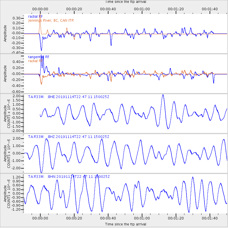
R33M Jennings River, BC, CAN - Earthquake Result Viewer
*The percent match for this event was below the threshold and hence no stack was calculated.
| Earthquake location: |
Northern Molucca Sea |
| Earthquake latitude/longitude: |
1.7/126.4 |
| Earthquake time(UTC): |
2019/11/14 (318) 22:34:21 GMT |
| Earthquake Depth: |
15 km |
| Earthquake Magnitude: |
5.3 Mww |
| Earthquake Catalog/Contributor: |
NEIC PDE/us |
|
| Network: |
TA USArray Transportable Network (new EarthScope stations) |
| Station: |
R33M Jennings River, BC, CAN |
| Lat/Lon: |
59.39 N/130.97 W |
| Elevation: |
1437 m |
|
| Distance: |
95.0 deg |
| Az: |
30.077 deg |
| Baz: |
281.738 deg |
| Ray Param: |
$rayparam |
*The percent match for this event was below the threshold and hence was not used in the summary stack. |
|
| Radial Match: |
37.265194 % |
| Radial Bump: |
400 |
| Transverse Match: |
69.48126 % |
| Transverse Bump: |
400 |
| SOD ConfigId: |
19951751 |
| Insert Time: |
2019-11-28 22:41:31.976 +0000 |
| GWidth: |
2.5 |
| Max Bumps: |
400 |
| Tol: |
0.001 |
|
Signal To Noise
| Channel | StoN | STA | LTA |
| TA:R33M: :BHZ:20191114T22:47:11.150025Z | 3.5677097 | 1.7100419E-6 | 4.7931087E-7 |
| TA:R33M: :BHN:20191114T22:47:11.150025Z | 1.2165905 | 4.506778E-7 | 3.704433E-7 |
| TA:R33M: :BHE:20191114T22:47:11.150025Z | 1.4723738 | 8.279152E-7 | 5.622996E-7 |
| Arrivals |
| Ps | |
| PpPs | |
| PsPs/PpSs | |


