You are here: Home > Network List > TA - USArray Transportable Network (new EarthScope stations) Stations List
> Station M31M Drury Creek, Yukon, CA > Earthquake Result Viewer
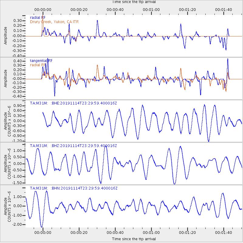
M31M Drury Creek, Yukon, CA - Earthquake Result Viewer
*The percent match for this event was below the threshold and hence no stack was calculated.
| Earthquake location: |
Northern Molucca Sea |
| Earthquake latitude/longitude: |
1.6/126.4 |
| Earthquake time(UTC): |
2019/11/14 (318) 23:17:22 GMT |
| Earthquake Depth: |
41 km |
| Earthquake Magnitude: |
5.5 Mww |
| Earthquake Catalog/Contributor: |
NEIC PDE/us |
|
| Network: |
TA USArray Transportable Network (new EarthScope stations) |
| Station: |
M31M Drury Creek, Yukon, CA |
| Lat/Lon: |
62.20 N/134.39 W |
| Elevation: |
639 m |
|
| Distance: |
92.9 deg |
| Az: |
27.601 deg |
| Baz: |
278.929 deg |
| Ray Param: |
$rayparam |
*The percent match for this event was below the threshold and hence was not used in the summary stack. |
|
| Radial Match: |
37.90076 % |
| Radial Bump: |
400 |
| Transverse Match: |
50.617935 % |
| Transverse Bump: |
400 |
| SOD ConfigId: |
19951751 |
| Insert Time: |
2019-11-28 23:22:59.353 +0000 |
| GWidth: |
2.5 |
| Max Bumps: |
400 |
| Tol: |
0.001 |
|
Signal To Noise
| Channel | StoN | STA | LTA |
| TA:M31M: :BHZ:20191114T23:29:59.400016Z | 1.380264 | 6.528578E-7 | 4.7299486E-7 |
| TA:M31M: :BHN:20191114T23:29:59.400016Z | 1.8541745 | 1.2902123E-6 | 6.9584195E-7 |
| TA:M31M: :BHE:20191114T23:29:59.400016Z | 0.60597026 | 2.1243012E-7 | 3.5056195E-7 |
| Arrivals |
| Ps | |
| PpPs | |
| PsPs/PpSs | |


