You are here: Home > Network List > TA - USArray Transportable Network (new EarthScope stations) Stations List
> Station P25A Willow Gulch Bison Ranch, Deer Trail, CO, USA > Earthquake Result Viewer
P25A Willow Gulch Bison Ranch, Deer Trail, CO, USA - Earthquake Result Viewer
| Earthquake location: |
Peru-Brazil Border Region |
| Earthquake latitude/longitude: |
-7.6/-74.4 |
| Earthquake time(UTC): |
2008/08/26 (239) 21:00:36 GMT |
| Earthquake Depth: |
154 km |
| Earthquake Magnitude: |
6.0 MB, 6.4 MW, 6.4 MW |
| Earthquake Catalog/Contributor: |
WHDF/NEIC |
|
| Network: |
TA USArray Transportable Network (new EarthScope stations) |
| Station: |
P25A Willow Gulch Bison Ranch, Deer Trail, CO, USA |
| Lat/Lon: |
39.51 N/104.17 W |
| Elevation: |
1753 m |
|
| Distance: |
54.4 deg |
| Az: |
331.801 deg |
| Baz: |
142.736 deg |
| Ray Param: |
0.06494534 |
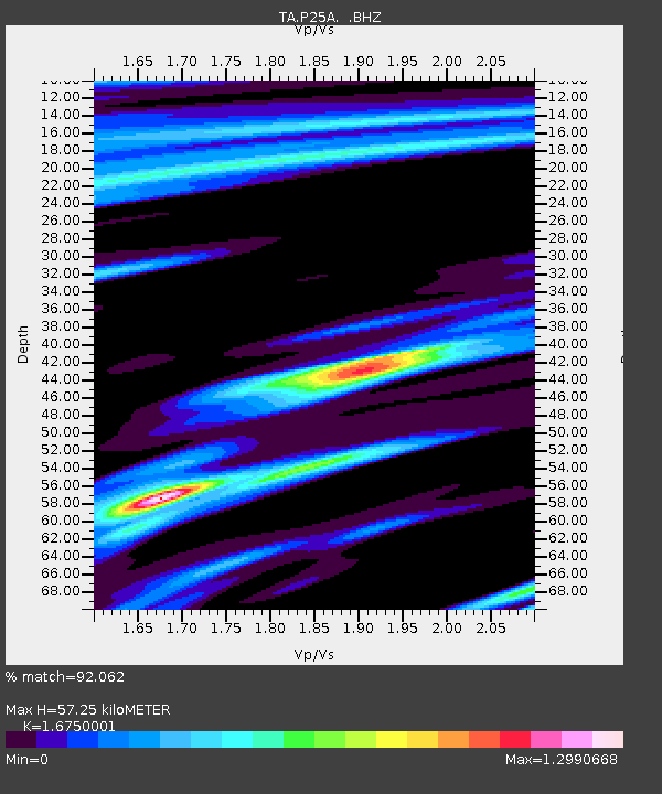
| Estimated Moho Depth: |
57.25 km |
| Estimated Crust Vp/Vs: |
1.68 |
| Assumed Crust Vp: |
6.159 km/s |
| Estimated Crust Vs: |
3.677 km/s |
| Estimated Crust Poisson's Ratio: |
0.22 |
|
| Radial Match: |
92.062 % |
| Radial Bump: |
400 |
| Transverse Match: |
65.329926 % |
| Transverse Bump: |
400 |
| SOD ConfigId: |
2504 |
| Insert Time: |
2010-03-07 05:52:36.307 +0000 |
| GWidth: |
2.5 |
| Max Bumps: |
400 |
| Tol: |
0.001 |
|

Signal To Noise
| Channel | StoN | STA | LTA |
| TA:P25A: :BHZ:20080826T21:09:17.200027Z | 17.97711 | 2.2444103E-6 | 1.2484823E-7 |
| TA:P25A: :BHN:20080826T21:09:17.200027Z | 4.230859 | 8.032554E-7 | 1.8985632E-7 |
| TA:P25A: :BHE:20080826T21:09:17.200027Z | 2.426248 | 5.149164E-7 | 2.1222742E-7 |
| Arrivals |
| Ps | 6.6 SECOND |
| PpPs | 24 SECOND |
| PsPs/PpSs | 30 SECOND |


