You are here: Home > Network List > TA - USArray Transportable Network (new EarthScope stations) Stations List
> Station P25A Willow Gulch Bison Ranch, Deer Trail, CO, USA > Earthquake Result Viewer
P25A Willow Gulch Bison Ranch, Deer Trail, CO, USA - Earthquake Result Viewer
| Earthquake location: |
Kermadec Islands Region |
| Earthquake latitude/longitude: |
-27.4/-176.3 |
| Earthquake time(UTC): |
2009/02/18 (049) 21:53:45 GMT |
| Earthquake Depth: |
25 km |
| Earthquake Magnitude: |
6.8 MB, 7.2 MS, 6.9 MW, 6.9 MW |
| Earthquake Catalog/Contributor: |
WHDF/NEIC |
|
| Network: |
TA USArray Transportable Network (new EarthScope stations) |
| Station: |
P25A Willow Gulch Bison Ranch, Deer Trail, CO, USA |
| Lat/Lon: |
39.51 N/104.17 W |
| Elevation: |
1753 m |
|
| Distance: |
94.6 deg |
| Az: |
47.624 deg |
| Baz: |
238.087 deg |
| Ray Param: |
0.04100351 |
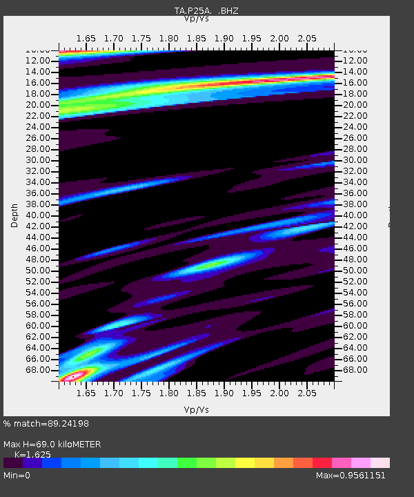
| Estimated Moho Depth: |
69.0 km |
| Estimated Crust Vp/Vs: |
1.62 |
| Assumed Crust Vp: |
6.159 km/s |
| Estimated Crust Vs: |
3.79 km/s |
| Estimated Crust Poisson's Ratio: |
0.20 |
|
| Radial Match: |
89.24198 % |
| Radial Bump: |
194 |
| Transverse Match: |
76.40841 % |
| Transverse Bump: |
245 |
| SOD ConfigId: |
2658 |
| Insert Time: |
2010-03-07 05:52:39.616 +0000 |
| GWidth: |
2.5 |
| Max Bumps: |
400 |
| Tol: |
0.001 |
|

Signal To Noise
| Channel | StoN | STA | LTA |
| TA:P25A: :BHZ:20090218T22:06:31.975002Z | 5.6115003 | 1.2662483E-6 | 2.2565237E-7 |
| TA:P25A: :BHN:20090218T22:06:31.975002Z | 0.81014955 | 9.0447537E-7 | 1.1164301E-6 |
| TA:P25A: :BHE:20090218T22:06:31.975002Z | 0.6683364 | 3.5209595E-7 | 5.2682446E-7 |
| Arrivals |
| Ps | 7.1 SECOND |
| PpPs | 29 SECOND |
| PsPs/PpSs | 36 SECOND |


