You are here: Home > Network List > TA - USArray Transportable Network (new EarthScope stations) Stations List
> Station P25A Willow Gulch Bison Ranch, Deer Trail, CO, USA > Earthquake Result Viewer
P25A Willow Gulch Bison Ranch, Deer Trail, CO, USA - Earthquake Result Viewer
| Earthquake location: |
Norwegian Sea |
| Earthquake latitude/longitude: |
72.2/0.9 |
| Earthquake time(UTC): |
2009/08/20 (232) 06:35:04 GMT |
| Earthquake Depth: |
6.0 km |
| Earthquake Magnitude: |
5.9 MB, 5.7 MS, 6.0 MW, 6.0 MW |
| Earthquake Catalog/Contributor: |
WHDF/NEIC |
|
| Network: |
TA USArray Transportable Network (new EarthScope stations) |
| Station: |
P25A Willow Gulch Bison Ranch, Deer Trail, CO, USA |
| Lat/Lon: |
39.51 N/104.17 W |
| Elevation: |
1753 m |
|
| Distance: |
57.3 deg |
| Az: |
297.381 deg |
| Baz: |
20.673 deg |
| Ray Param: |
0.06361881 |
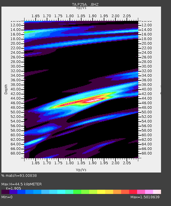
| Estimated Moho Depth: |
44.5 km |
| Estimated Crust Vp/Vs: |
1.90 |
| Assumed Crust Vp: |
6.159 km/s |
| Estimated Crust Vs: |
3.233 km/s |
| Estimated Crust Poisson's Ratio: |
0.31 |
|
| Radial Match: |
93.00838 % |
| Radial Bump: |
397 |
| Transverse Match: |
75.08511 % |
| Transverse Bump: |
400 |
| SOD ConfigId: |
2622 |
| Insert Time: |
2010-03-07 05:52:44.596 +0000 |
| GWidth: |
2.5 |
| Max Bumps: |
400 |
| Tol: |
0.001 |
|
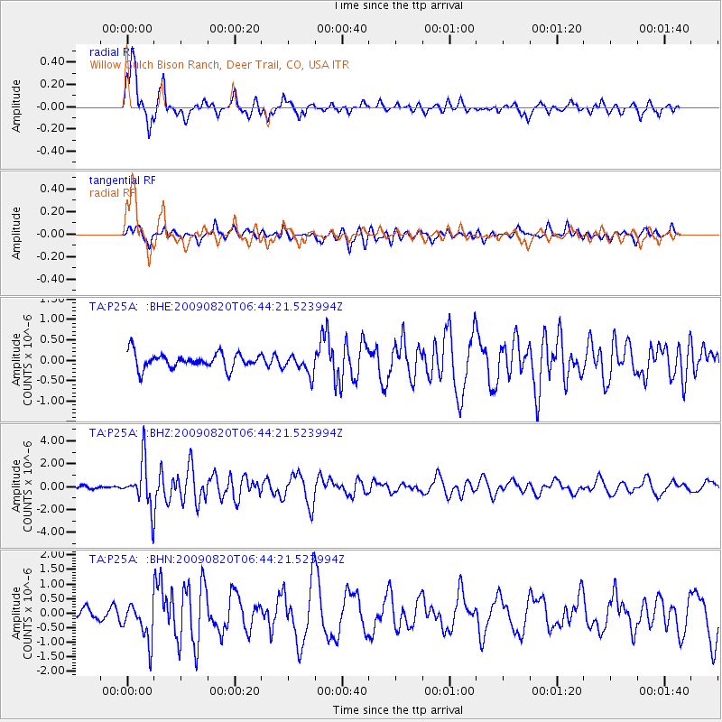
Signal To Noise
| Channel | StoN | STA | LTA |
| TA:P25A: :BHZ:20090820T06:44:21.523994Z | 14.364069 | 2.0130306E-6 | 1.4014348E-7 |
| TA:P25A: :BHN:20090820T06:44:21.523994Z | 3.6076276 | 6.6350225E-7 | 1.839165E-7 |
| TA:P25A: :BHE:20090820T06:44:21.523994Z | 1.3442668 | 2.5001313E-7 | 1.8598477E-7 |
| Arrivals |
| Ps | 6.8 SECOND |
| PpPs | 20 SECOND |
| PsPs/PpSs | 27 SECOND |


