You are here: Home > Network List > TA - USArray Transportable Network (new EarthScope stations) Stations List
> Station P25A Willow Gulch Bison Ranch, Deer Trail, CO, USA > Earthquake Result Viewer
P25A Willow Gulch Bison Ranch, Deer Trail, CO, USA - Earthquake Result Viewer
| Earthquake location: |
Samoa Islands Region |
| Earthquake latitude/longitude: |
-15.2/-172.6 |
| Earthquake time(UTC): |
2009/08/30 (242) 14:51:32 GMT |
| Earthquake Depth: |
11 km |
| Earthquake Magnitude: |
6.4 MB, 6.3 MS, 6.6 MW, 6.6 MW |
| Earthquake Catalog/Contributor: |
WHDF/NEIC |
|
| Network: |
TA USArray Transportable Network (new EarthScope stations) |
| Station: |
P25A Willow Gulch Bison Ranch, Deer Trail, CO, USA |
| Lat/Lon: |
39.51 N/104.17 W |
| Elevation: |
1753 m |
|
| Distance: |
83.7 deg |
| Az: |
46.354 deg |
| Baz: |
244.557 deg |
| Ray Param: |
0.045990765 |
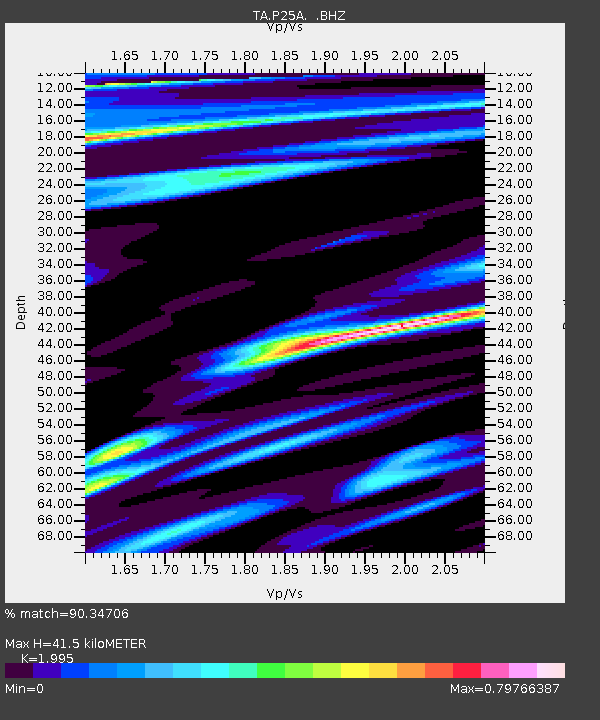
| Estimated Moho Depth: |
41.5 km |
| Estimated Crust Vp/Vs: |
2.00 |
| Assumed Crust Vp: |
6.159 km/s |
| Estimated Crust Vs: |
3.087 km/s |
| Estimated Crust Poisson's Ratio: |
0.33 |
|
| Radial Match: |
90.34706 % |
| Radial Bump: |
374 |
| Transverse Match: |
75.84322 % |
| Transverse Bump: |
400 |
| SOD ConfigId: |
2622 |
| Insert Time: |
2010-03-07 05:52:46.673 +0000 |
| GWidth: |
2.5 |
| Max Bumps: |
400 |
| Tol: |
0.001 |
|

Signal To Noise
| Channel | StoN | STA | LTA |
| TA:P25A: :BHZ:20090830T15:03:30.225022Z | 29.432951 | 5.2659475E-6 | 1.7891334E-7 |
| TA:P25A: :BHN:20090830T15:03:30.225022Z | 1.0104464 | 5.752742E-7 | 5.6932674E-7 |
| TA:P25A: :BHE:20090830T15:03:30.225022Z | 1.9349172 | 8.6944027E-7 | 4.4934237E-7 |
| Arrivals |
| Ps | 6.8 SECOND |
| PpPs | 20 SECOND |
| PsPs/PpSs | 27 SECOND |


