You are here: Home > Network List > TA - USArray Transportable Network (new EarthScope stations) Stations List
> Station C16K Lisburne Hills, AK, USA > Earthquake Result Viewer
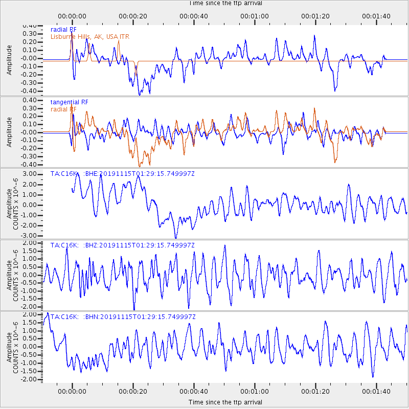
C16K Lisburne Hills, AK, USA - Earthquake Result Viewer
*The percent match for this event was below the threshold and hence no stack was calculated.
| Earthquake location: |
Northern Molucca Sea |
| Earthquake latitude/longitude: |
1.6/126.4 |
| Earthquake time(UTC): |
2019/11/15 (319) 01:17:38 GMT |
| Earthquake Depth: |
44 km |
| Earthquake Magnitude: |
5.9 Mww |
| Earthquake Catalog/Contributor: |
NEIC PDE/us |
|
| Network: |
TA USArray Transportable Network (new EarthScope stations) |
| Station: |
C16K Lisburne Hills, AK, USA |
| Lat/Lon: |
68.27 N/165.34 W |
| Elevation: |
102 m |
|
| Distance: |
80.6 deg |
| Az: |
20.526 deg |
| Baz: |
250.293 deg |
| Ray Param: |
$rayparam |
*The percent match for this event was below the threshold and hence was not used in the summary stack. |
|
| Radial Match: |
21.646215 % |
| Radial Bump: |
400 |
| Transverse Match: |
51.538933 % |
| Transverse Bump: |
400 |
| SOD ConfigId: |
19951751 |
| Insert Time: |
2019-11-29 01:26:50.928 +0000 |
| GWidth: |
2.5 |
| Max Bumps: |
400 |
| Tol: |
0.001 |
|
Signal To Noise
| Channel | StoN | STA | LTA |
| TA:C16K: :BHZ:20191115T01:29:15.749997Z | 1.078982 | 6.9079925E-7 | 6.4023243E-7 |
| TA:C16K: :BHN:20191115T01:29:15.749997Z | 2.510982 | 1.8825083E-6 | 7.4971E-7 |
| TA:C16K: :BHE:20191115T01:29:15.749997Z | 3.1354597 | 3.169082E-6 | 1.0107232E-6 |
| Arrivals |
| Ps | |
| PpPs | |
| PsPs/PpSs | |


