You are here: Home > Network List > TA - USArray Transportable Network (new EarthScope stations) Stations List
> Station P25A Willow Gulch Bison Ranch, Deer Trail, CO, USA > Earthquake Result Viewer
P25A Willow Gulch Bison Ranch, Deer Trail, CO, USA - Earthquake Result Viewer
| Earthquake location: |
Kuril Islands |
| Earthquake latitude/longitude: |
46.0/151.5 |
| Earthquake time(UTC): |
2009/04/07 (097) 04:23:33 GMT |
| Earthquake Depth: |
31 km |
| Earthquake Magnitude: |
6.5 MB, 6.8 MS, 6.9 MW, 6.9 MW |
| Earthquake Catalog/Contributor: |
WHDF/NEIC |
|
| Network: |
TA USArray Transportable Network (new EarthScope stations) |
| Station: |
P25A Willow Gulch Bison Ranch, Deer Trail, CO, USA |
| Lat/Lon: |
39.51 N/104.17 W |
| Elevation: |
1753 m |
|
| Distance: |
71.2 deg |
| Az: |
52.353 deg |
| Baz: |
314.533 deg |
| Ray Param: |
0.054423876 |
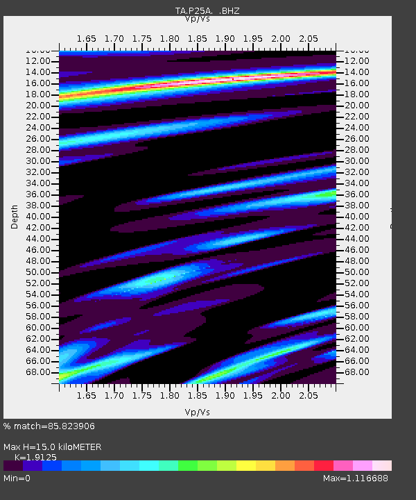
| Estimated Moho Depth: |
15.0 km |
| Estimated Crust Vp/Vs: |
1.91 |
| Assumed Crust Vp: |
6.159 km/s |
| Estimated Crust Vs: |
3.22 km/s |
| Estimated Crust Poisson's Ratio: |
0.31 |
|
| Radial Match: |
85.823906 % |
| Radial Bump: |
385 |
| Transverse Match: |
56.132935 % |
| Transverse Bump: |
400 |
| SOD ConfigId: |
2658 |
| Insert Time: |
2010-03-07 05:53:08.701 +0000 |
| GWidth: |
2.5 |
| Max Bumps: |
400 |
| Tol: |
0.001 |
|

Signal To Noise
| Channel | StoN | STA | LTA |
| TA:P25A: :BHZ:20090407T04:34:18.225012Z | 23.900331 | 5.85135E-6 | 2.4482296E-7 |
| TA:P25A: :BHN:20090407T04:34:18.225012Z | 1.9200252 | 1.7827814E-6 | 9.285198E-7 |
| TA:P25A: :BHE:20090407T04:34:18.225012Z | 1.705235 | 1.4917482E-6 | 8.7480504E-7 |
| Arrivals |
| Ps | 2.3 SECOND |
| PpPs | 6.9 SECOND |
| PsPs/PpSs | 9.2 SECOND |


