You are here: Home > Network List > TS - TERRAscope (Southern California Seismic Network) Stations List
> Station PAS Pasadena, California, USA > Earthquake Result Viewer
PAS Pasadena, California, USA - Earthquake Result Viewer
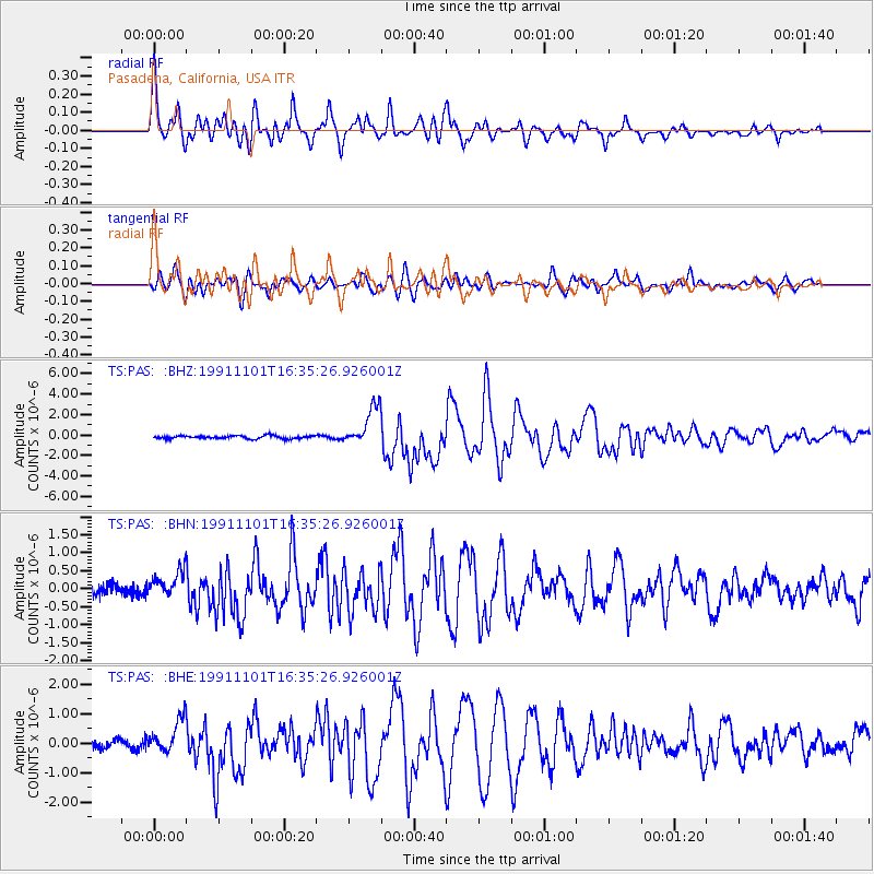
| Earthquake location: |
Kermadec Islands, New Zealand |
| Earthquake latitude/longitude: |
-30.1/-178.0 |
| Earthquake time(UTC): |
1991/11/01 (305) 16:23:26 GMT |
| Earthquake Depth: |
48 km |
| Earthquake Magnitude: |
6.4 MB, 6.5 MS, 6.7 UNKNOWN |
| Earthquake Catalog/Contributor: |
WHDF/NEIC |
|
| Network: |
TS TERRAscope (Southern California Seismic Network) |
| Station: |
PAS Pasadena, California, USA |
| Lat/Lon: |
34.15 N/118.17 W |
| Elevation: |
295 m |
|
| Distance: |
85.3 deg |
| Az: |
45.999 deg |
| Baz: |
228.727 deg |
| Ray Param: |
0.044803705 |
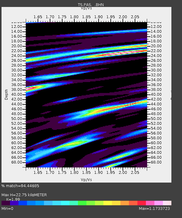
| Estimated Moho Depth: |
22.75 km |
| Estimated Crust Vp/Vs: |
1.99 |
| Assumed Crust Vp: |
6.1 km/s |
| Estimated Crust Vs: |
3.065 km/s |
| Estimated Crust Poisson's Ratio: |
0.33 |
|
| Radial Match: |
94.44685 % |
| Radial Bump: |
400 |
| Transverse Match: |
88.1903 % |
| Transverse Bump: |
400 |
| SOD ConfigId: |
16938 |
| Insert Time: |
2010-02-26 14:34:25.943 +0000 |
| GWidth: |
2.5 |
| Max Bumps: |
400 |
| Tol: |
0.001 |
|
Signal To Noise
| Channel | StoN | STA | LTA |
| TS:PAS: :BHN:19911101T16:35:26.926001Z | 2.5405023 | 3.5338607E-7 | 1.3910088E-7 |
| TS:PAS: :BHE:19911101T16:35:26.926001Z | 4.007092 | 5.502202E-7 | 1.373116E-7 |
| TS:PAS: :BHZ:19911101T16:35:26.926001Z | 12.861151 | 1.8848083E-6 | 1.4655052E-7 |
| Arrivals |
| Ps | 3.8 SECOND |
| PpPs | 11 SECOND |
| PsPs/PpSs | 15 SECOND |


