You are here: Home > Network List > TA - USArray Transportable Network (new EarthScope stations) Stations List
> Station TOLK Toolik Lake Research Station, AK, USA > Earthquake Result Viewer
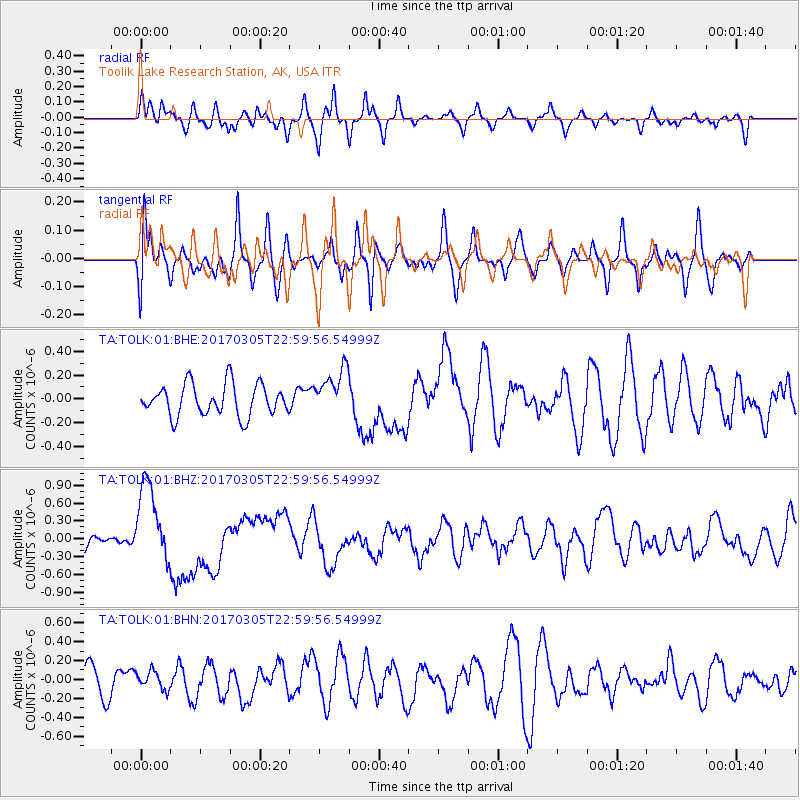
TOLK Toolik Lake Research Station, AK, USA - Earthquake Result Viewer
*The percent match for this event was below the threshold and hence no stack was calculated.
| Earthquake location: |
New Britain Region, P.N.G. |
| Earthquake latitude/longitude: |
-6.0/149.4 |
| Earthquake time(UTC): |
2017/03/05 (064) 22:47:53 GMT |
| Earthquake Depth: |
31 km |
| Earthquake Magnitude: |
6.3 mww |
| Earthquake Catalog/Contributor: |
NEIC PDE/us |
|
| Network: |
TA USArray Transportable Network (new EarthScope stations) |
| Station: |
TOLK Toolik Lake Research Station, AK, USA |
| Lat/Lon: |
68.64 N/149.57 W |
| Elevation: |
760 m |
|
| Distance: |
85.4 deg |
| Az: |
18.763 deg |
| Baz: |
240.844 deg |
| Ray Param: |
$rayparam |
*The percent match for this event was below the threshold and hence was not used in the summary stack. |
|
| Radial Match: |
63.18389 % |
| Radial Bump: |
400 |
| Transverse Match: |
65.034744 % |
| Transverse Bump: |
400 |
| SOD ConfigId: |
1992691 |
| Insert Time: |
2017-03-19 22:50:10.714 +0000 |
| GWidth: |
2.5 |
| Max Bumps: |
400 |
| Tol: |
0.001 |
|
Signal To Noise
| Channel | StoN | STA | LTA |
| TA:TOLK:01:BHZ:20170305T22:59:56.54999Z | 4.0165844 | 6.802926E-7 | 1.6937092E-7 |
| TA:TOLK:01:BHN:20170305T22:59:56.54999Z | 0.56141984 | 9.6110234E-8 | 1.7119136E-7 |
| TA:TOLK:01:BHE:20170305T22:59:56.54999Z | 1.4774616 | 1.9639621E-7 | 1.3292814E-7 |
| Arrivals |
| Ps | |
| PpPs | |
| PsPs/PpSs | |


