You are here: Home > Network List > TA - USArray Transportable Network (new EarthScope stations) Stations List
> Station E20K Nigu River, AK, USA > Earthquake Result Viewer
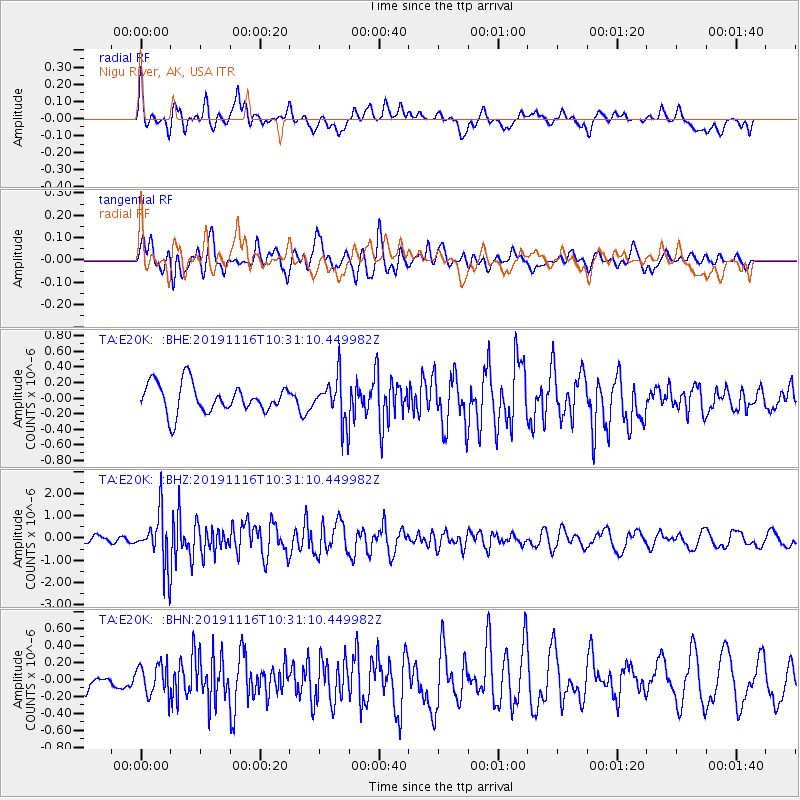
E20K Nigu River, AK, USA - Earthquake Result Viewer
*The percent match for this event was below the threshold and hence no stack was calculated.
| Earthquake location: |
Northern Molucca Sea |
| Earthquake latitude/longitude: |
1.5/126.3 |
| Earthquake time(UTC): |
2019/11/16 (320) 10:19:15 GMT |
| Earthquake Depth: |
35 km |
| Earthquake Magnitude: |
5.8 Mww |
| Earthquake Catalog/Contributor: |
NEIC PDE/us |
|
| Network: |
TA USArray Transportable Network (new EarthScope stations) |
| Station: |
E20K Nigu River, AK, USA |
| Lat/Lon: |
68.26 N/156.19 W |
| Elevation: |
866 m |
|
| Distance: |
83.9 deg |
| Az: |
21.455 deg |
| Baz: |
258.922 deg |
| Ray Param: |
$rayparam |
*The percent match for this event was below the threshold and hence was not used in the summary stack. |
|
| Radial Match: |
68.13084 % |
| Radial Bump: |
400 |
| Transverse Match: |
61.823383 % |
| Transverse Bump: |
400 |
| SOD ConfigId: |
19951751 |
| Insert Time: |
2019-11-30 10:27:08.889 +0000 |
| GWidth: |
2.5 |
| Max Bumps: |
400 |
| Tol: |
0.001 |
|
Signal To Noise
| Channel | StoN | STA | LTA |
| TA:E20K: :BHZ:20191116T10:31:10.449982Z | 5.9970093 | 1.1814798E-6 | 1.970115E-7 |
| TA:E20K: :BHN:20191116T10:31:10.449982Z | 1.8464386 | 1.8437599E-7 | 9.985492E-8 |
| TA:E20K: :BHE:20191116T10:31:10.449982Z | 1.5638162 | 2.893398E-7 | 1.8502162E-7 |
| Arrivals |
| Ps | |
| PpPs | |
| PsPs/PpSs | |


