You are here: Home > Network List > TA - USArray Transportable Network (new EarthScope stations) Stations List
> Station F20K Avaraart Lake, AK, USA > Earthquake Result Viewer
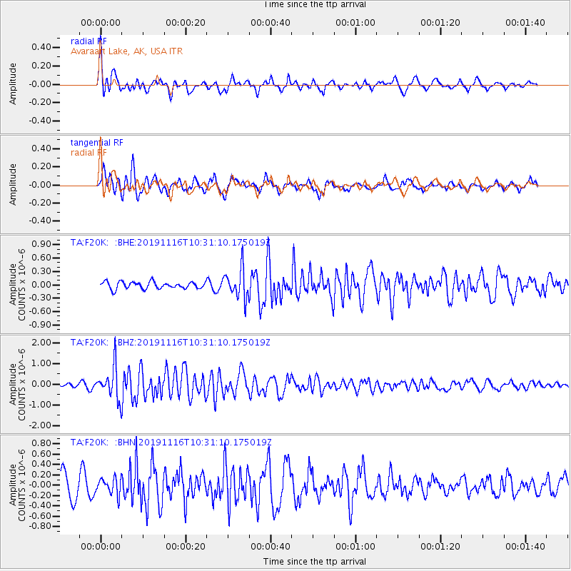
F20K Avaraart Lake, AK, USA - Earthquake Result Viewer
*The percent match for this event was below the threshold and hence no stack was calculated.
| Earthquake location: |
Northern Molucca Sea |
| Earthquake latitude/longitude: |
1.5/126.3 |
| Earthquake time(UTC): |
2019/11/16 (320) 10:19:15 GMT |
| Earthquake Depth: |
35 km |
| Earthquake Magnitude: |
5.8 Mww |
| Earthquake Catalog/Contributor: |
NEIC PDE/us |
|
| Network: |
TA USArray Transportable Network (new EarthScope stations) |
| Station: |
F20K Avaraart Lake, AK, USA |
| Lat/Lon: |
67.05 N/155.73 W |
| Elevation: |
136 m |
|
| Distance: |
83.9 deg |
| Az: |
22.689 deg |
| Baz: |
259.481 deg |
| Ray Param: |
$rayparam |
*The percent match for this event was below the threshold and hence was not used in the summary stack. |
|
| Radial Match: |
76.537186 % |
| Radial Bump: |
400 |
| Transverse Match: |
61.41519 % |
| Transverse Bump: |
400 |
| SOD ConfigId: |
19951751 |
| Insert Time: |
2019-11-30 10:27:13.971 +0000 |
| GWidth: |
2.5 |
| Max Bumps: |
400 |
| Tol: |
0.001 |
|
Signal To Noise
| Channel | StoN | STA | LTA |
| TA:F20K: :BHZ:20191116T10:31:10.175019Z | 5.7311854 | 8.0159293E-7 | 1.3986512E-7 |
| TA:F20K: :BHN:20191116T10:31:10.175019Z | 0.97527176 | 1.6268851E-7 | 1.6681352E-7 |
| TA:F20K: :BHE:20191116T10:31:10.175019Z | 4.3422065 | 3.3445255E-7 | 7.7023635E-8 |
| Arrivals |
| Ps | |
| PpPs | |
| PsPs/PpSs | |


