You are here: Home > Network List > TS - TERRAscope (Southern California Seismic Network) Stations List
> Station PAS Pasadena, California, USA > Earthquake Result Viewer
PAS Pasadena, California, USA - Earthquake Result Viewer
| Earthquake location: |
Off E. Coast Of N. Island, N.Z. |
| Earthquake latitude/longitude: |
-36.6/178.1 |
| Earthquake time(UTC): |
1991/11/20 (324) 09:23:12 GMT |
| Earthquake Depth: |
102 km |
| Earthquake Magnitude: |
6.1 MB |
| Earthquake Catalog/Contributor: |
WHDF/NEIC |
|
| Network: |
TS TERRAscope (Southern California Seismic Network) |
| Station: |
PAS Pasadena, California, USA |
| Lat/Lon: |
34.15 N/118.17 W |
| Elevation: |
295 m |
|
| Distance: |
92.1 deg |
| Az: |
48.085 deg |
| Baz: |
226.248 deg |
| Ray Param: |
0.04147349 |
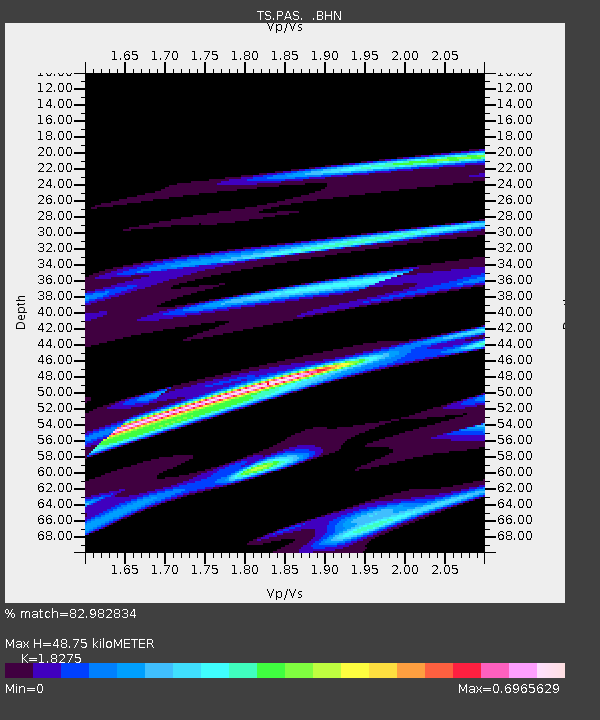
| Estimated Moho Depth: |
48.75 km |
| Estimated Crust Vp/Vs: |
1.83 |
| Assumed Crust Vp: |
6.1 km/s |
| Estimated Crust Vs: |
3.338 km/s |
| Estimated Crust Poisson's Ratio: |
0.29 |
|
| Radial Match: |
82.982834 % |
| Radial Bump: |
400 |
| Transverse Match: |
41.21153 % |
| Transverse Bump: |
280 |
| SOD ConfigId: |
16938 |
| Insert Time: |
2010-02-26 14:34:27.169 +0000 |
| GWidth: |
2.5 |
| Max Bumps: |
400 |
| Tol: |
0.001 |
|
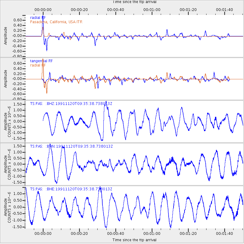
Signal To Noise
| Channel | StoN | STA | LTA |
| TS:PAS: :BHN:19911120T09:35:38.738013Z | 1.0803319 | 9.2804163E-7 | 8.5903383E-7 |
| TS:PAS: :BHE:19911120T09:35:38.738013Z | 0.52506125 | 5.866883E-7 | 1.1173712E-6 |
| TS:PAS: :BHZ:19911120T09:35:38.738013Z | 2.2267106 | 1.1933342E-6 | 5.35918E-7 |
| Arrivals |
| Ps | 6.7 SECOND |
| PpPs | 22 SECOND |
| PsPs/PpSs | 29 SECOND |


