You are here: Home > Network List > IU - Global Seismograph Network (GSN - IRIS/USGS) Stations List
> Station PMG Port Moresby, New Guinea > Earthquake Result Viewer
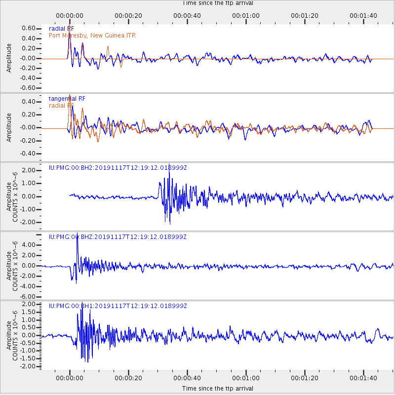
PMG Port Moresby, New Guinea - Earthquake Result Viewer
*The percent match for this event was below the threshold and hence no stack was calculated.
| Earthquake location: |
Fiji Islands Region |
| Earthquake latitude/longitude: |
-20.8/-177.8 |
| Earthquake time(UTC): |
2019/11/17 (321) 12:13:27 GMT |
| Earthquake Depth: |
494 km |
| Earthquake Magnitude: |
5.8 Mww |
| Earthquake Catalog/Contributor: |
NEIC PDE/us |
|
| Network: |
IU Global Seismograph Network (GSN - IRIS/USGS) |
| Station: |
PMG Port Moresby, New Guinea |
| Lat/Lon: |
9.40 S/147.16 E |
| Elevation: |
90 m |
|
| Distance: |
35.6 deg |
| Az: |
283.26 deg |
| Baz: |
112.649 deg |
| Ray Param: |
$rayparam |
*The percent match for this event was below the threshold and hence was not used in the summary stack. |
|
| Radial Match: |
73.046646 % |
| Radial Bump: |
400 |
| Transverse Match: |
69.59144 % |
| Transverse Bump: |
400 |
| SOD ConfigId: |
19951751 |
| Insert Time: |
2019-12-01 12:20:01.276 +0000 |
| GWidth: |
2.5 |
| Max Bumps: |
400 |
| Tol: |
0.001 |
|
Signal To Noise
| Channel | StoN | STA | LTA |
| IU:PMG:00:BHZ:20191117T12:19:12.018999Z | 22.296913 | 1.7946498E-6 | 8.048871E-8 |
| IU:PMG:00:BH1:20191117T12:19:12.018999Z | 7.8927894 | 6.5584146E-7 | 8.3093745E-8 |
| IU:PMG:00:BH2:20191117T12:19:12.018999Z | 11.228515 | 8.951671E-7 | 7.972266E-8 |
| Arrivals |
| Ps | |
| PpPs | |
| PsPs/PpSs | |


