You are here: Home > Network List > GS - US Geological Survey Networks Stations List
> Station KS21 NEIC Portable/Temp deployment > Earthquake Result Viewer
KS21 NEIC Portable/Temp deployment - Earthquake Result Viewer
| Earthquake location: |
Hokkaido, Japan Region |
| Earthquake latitude/longitude: |
41.5/141.9 |
| Earthquake time(UTC): |
2017/03/07 (066) 16:08:18 GMT |
| Earthquake Depth: |
50 km |
| Earthquake Magnitude: |
5.7 Mww |
| Earthquake Catalog/Contributor: |
NEIC PDE/us |
|
| Network: |
GS US Geological Survey Networks |
| Station: |
KS21 NEIC Portable/Temp deployment |
| Lat/Lon: |
37.29 N/97.66 W |
| Elevation: |
414 m |
|
| Distance: |
84.5 deg |
| Az: |
43.69 deg |
| Baz: |
319.445 deg |
| Ray Param: |
0.04532437 |
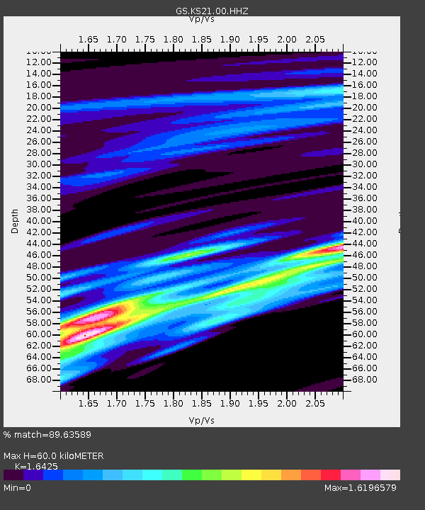
| Estimated Moho Depth: |
60.0 km |
| Estimated Crust Vp/Vs: |
1.64 |
| Assumed Crust Vp: |
6.483 km/s |
| Estimated Crust Vs: |
3.947 km/s |
| Estimated Crust Poisson's Ratio: |
0.21 |
|
| Radial Match: |
89.63589 % |
| Radial Bump: |
346 |
| Transverse Match: |
69.90573 % |
| Transverse Bump: |
321 |
| SOD ConfigId: |
1992691 |
| Insert Time: |
2017-03-21 16:09:40.964 +0000 |
| GWidth: |
2.5 |
| Max Bumps: |
400 |
| Tol: |
0.001 |
|

Signal To Noise
| Channel | StoN | STA | LTA |
| GS:KS21:00:HHZ:20170307T16:20:15.214014Z | 0.86974645 | 4.800524E-7 | 5.519452E-7 |
| GS:KS21:00:HH1:20170307T16:20:15.214014Z | 2.0891802 | 1.4989788E-6 | 7.1749616E-7 |
| GS:KS21:00:HH2:20170307T16:20:15.214014Z | 1.0607485 | 2.0906625E-6 | 1.9709314E-6 |
| Arrivals |
| Ps | 6.1 SECOND |
| PpPs | 24 SECOND |
| PsPs/PpSs | 30 SECOND |


