You are here: Home > Network List > TA - USArray Transportable Network (new EarthScope stations) Stations List
> Station H31M Peel River, Yukon, CAN > Earthquake Result Viewer
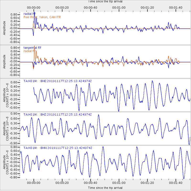
H31M Peel River, Yukon, CAN - Earthquake Result Viewer
*The percent match for this event was below the threshold and hence no stack was calculated.
| Earthquake location: |
Fiji Islands Region |
| Earthquake latitude/longitude: |
-20.8/-177.8 |
| Earthquake time(UTC): |
2019/11/17 (321) 12:13:27 GMT |
| Earthquake Depth: |
494 km |
| Earthquake Magnitude: |
5.8 Mww |
| Earthquake Catalog/Contributor: |
NEIC PDE/us |
|
| Network: |
TA USArray Transportable Network (new EarthScope stations) |
| Station: |
H31M Peel River, Yukon, CAN |
| Lat/Lon: |
65.81 N/134.34 W |
| Elevation: |
642 m |
|
| Distance: |
92.4 deg |
| Az: |
16.488 deg |
| Baz: |
220.112 deg |
| Ray Param: |
$rayparam |
*The percent match for this event was below the threshold and hence was not used in the summary stack. |
|
| Radial Match: |
58.263325 % |
| Radial Bump: |
400 |
| Transverse Match: |
54.323467 % |
| Transverse Bump: |
385 |
| SOD ConfigId: |
19951751 |
| Insert Time: |
2019-12-01 12:21:52.934 +0000 |
| GWidth: |
2.5 |
| Max Bumps: |
400 |
| Tol: |
0.001 |
|
Signal To Noise
| Channel | StoN | STA | LTA |
| TA:H31M: :BHZ:20191117T12:25:13.424974Z | 2.3790128 | 4.892894E-7 | 2.056691E-7 |
| TA:H31M: :BHN:20191117T12:25:13.424974Z | 0.38387874 | 2.0819472E-7 | 5.4234505E-7 |
| TA:H31M: :BHE:20191117T12:25:13.424974Z | 2.0012047 | 3.784813E-7 | 1.8912672E-7 |
| Arrivals |
| Ps | |
| PpPs | |
| PsPs/PpSs | |


