You are here: Home > Network List > TS - TERRAscope (Southern California Seismic Network) Stations List
> Station PAS Pasadena, California, USA > Earthquake Result Viewer
PAS Pasadena, California, USA - Earthquake Result Viewer
| Earthquake location: |
Rat Islands, Aleutian Islands |
| Earthquake latitude/longitude: |
52.0/178.9 |
| Earthquake time(UTC): |
1991/01/23 (023) 01:12:30 GMT |
| Earthquake Depth: |
116 km |
| Earthquake Magnitude: |
5.9 MB |
| Earthquake Catalog/Contributor: |
WHDF/NEIC |
|
| Network: |
TS TERRAscope (Southern California Seismic Network) |
| Station: |
PAS Pasadena, California, USA |
| Lat/Lon: |
34.15 N/118.17 W |
| Elevation: |
295 m |
|
| Distance: |
47.8 deg |
| Az: |
86.204 deg |
| Baz: |
311.966 deg |
| Ray Param: |
0.06940164 |
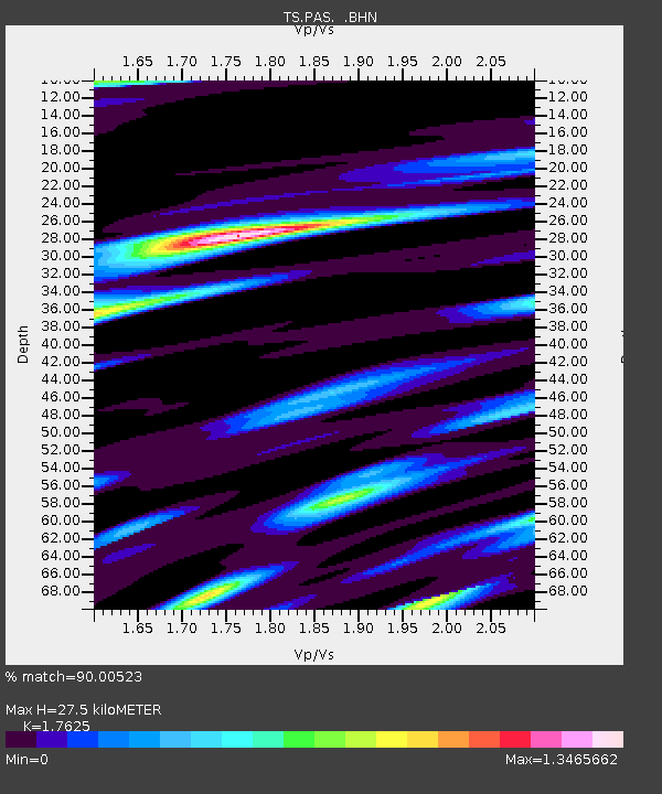
| Estimated Moho Depth: |
27.5 km |
| Estimated Crust Vp/Vs: |
1.76 |
| Assumed Crust Vp: |
6.1 km/s |
| Estimated Crust Vs: |
3.461 km/s |
| Estimated Crust Poisson's Ratio: |
0.26 |
|
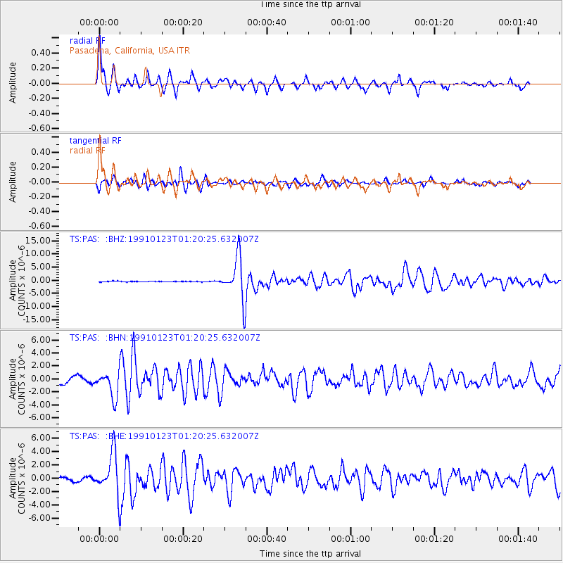
| Radial Match: |
90.00523 % |
| Radial Bump: |
304 |
| Transverse Match: |
77.44138 % |
| Transverse Bump: |
400 |
| SOD ConfigId: |
17000 |
| Insert Time: |
2010-02-26 14:34:31.022 +0000 |
| GWidth: |
2.5 |
| Max Bumps: |
400 |
| Tol: |
0.001 |
|
Signal To Noise
| Channel | StoN | STA | LTA |
| TS:PAS: :BHN:19910123T01:20:25.632007Z | 3.1615226 | 2.071125E-6 | 6.5510363E-7 |
| TS:PAS: :BHE:19910123T01:20:25.632007Z | 11.981156 | 3.233256E-6 | 2.6986174E-7 |
| TS:PAS: :BHZ:19910123T01:20:25.632007Z | 64.216156 | 8.321428E-6 | 1.2958465E-7 |
| Arrivals |
| Ps | 3.6 SECOND |
| PpPs | 12 SECOND |
| PsPs/PpSs | 15 SECOND |


