You are here: Home > Network List > TS - TERRAscope (Southern California Seismic Network) Stations List
> Station PAS Pasadena, California, USA > Earthquake Result Viewer
PAS Pasadena, California, USA - Earthquake Result Viewer

| Earthquake location: |
Kuril Islands |
| Earthquake latitude/longitude: |
48.7/154.9 |
| Earthquake time(UTC): |
1991/07/13 (194) 12:15:13 GMT |
| Earthquake Depth: |
40 km |
| Earthquake Magnitude: |
5.7 MB, 5.9 MS, 5.7 UNKNOWN |
| Earthquake Catalog/Contributor: |
WHDF/NEIC |
|
| Network: |
TS TERRAscope (Southern California Seismic Network) |
| Station: |
PAS Pasadena, California, USA |
| Lat/Lon: |
34.15 N/118.17 W |
| Elevation: |
295 m |
|
| Distance: |
63.3 deg |
| Az: |
67.906 deg |
| Baz: |
312.291 deg |
| Ray Param: |
0.059561443 |
| Estimated Moho Depth: |
28.25 km |
| Estimated Crust Vp/Vs: |
1.75 |
| Assumed Crust Vp: |
6.1 km/s |
| Estimated Crust Vs: |
3.496 km/s |
| Estimated Crust Poisson's Ratio: |
0.26 |
|
| Radial Match: |
89.618355 % |
| Radial Bump: |
383 |
| Transverse Match: |
84.772835 % |
| Transverse Bump: |
400 |
| SOD ConfigId: |
17000 |
| Insert Time: |
2010-02-26 14:34:32.713 +0000 |
| GWidth: |
2.5 |
| Max Bumps: |
400 |
| Tol: |
0.001 |
|
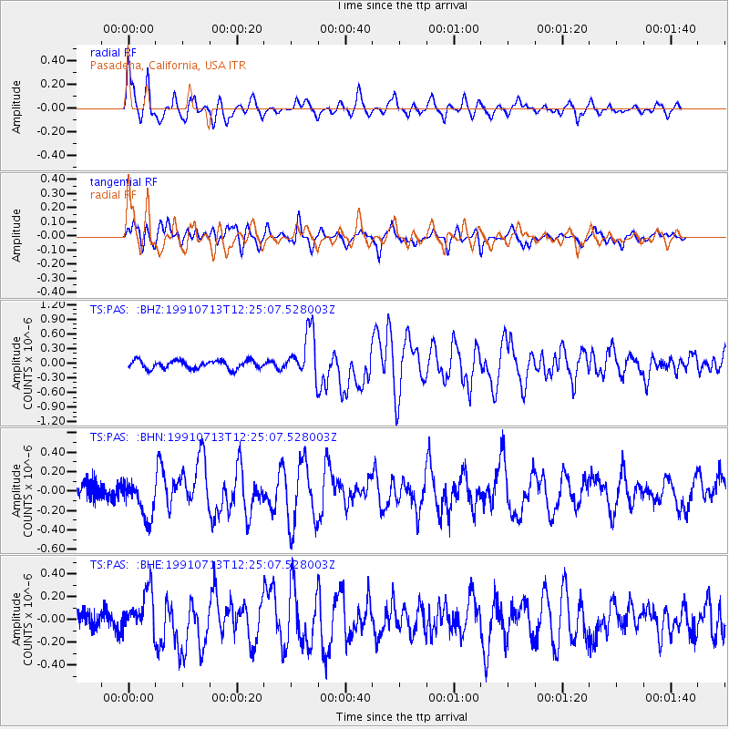
Signal To Noise
| Channel | StoN | STA | LTA |
| TS:PAS: :BHN:19910713T12:25:07.528003Z | 2.2959776 | 1.9551612E-7 | 8.515593E-8 |
| TS:PAS: :BHE:19910713T12:25:07.528003Z | 2.6345527 | 1.885912E-7 | 7.158376E-8 |
| TS:PAS: :BHZ:19910713T12:25:07.528003Z | 5.6939936 | 4.826272E-7 | 8.476075E-8 |
| Arrivals |
| Ps | 3.6 SECOND |
| PpPs | 12 SECOND |
| PsPs/PpSs | 16 SECOND |


