You are here: Home > Network List > TS - TERRAscope (Southern California Seismic Network) Stations List
> Station PAS Pasadena, California, USA > Earthquake Result Viewer
PAS Pasadena, California, USA - Earthquake Result Viewer
| Earthquake location: |
Southern East Pacific Rise |
| Earthquake latitude/longitude: |
-17.8/-116.0 |
| Earthquake time(UTC): |
1991/09/03 (246) 11:56:16 GMT |
| Earthquake Depth: |
10 km |
| Earthquake Magnitude: |
5.8 MB, 5.9 MS |
| Earthquake Catalog/Contributor: |
WHDF/NEIC |
|
| Network: |
TS TERRAscope (Southern California Seismic Network) |
| Station: |
PAS Pasadena, California, USA |
| Lat/Lon: |
34.15 N/118.17 W |
| Elevation: |
295 m |
|
| Distance: |
51.7 deg |
| Az: |
357.666 deg |
| Baz: |
177.32 deg |
| Ray Param: |
0.067210704 |
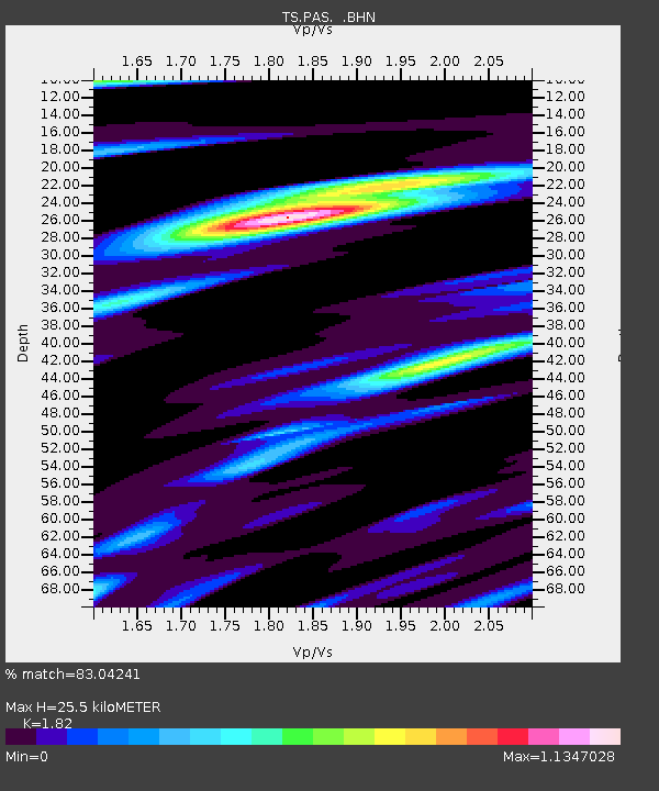
| Estimated Moho Depth: |
25.5 km |
| Estimated Crust Vp/Vs: |
1.82 |
| Assumed Crust Vp: |
6.1 km/s |
| Estimated Crust Vs: |
3.352 km/s |
| Estimated Crust Poisson's Ratio: |
0.28 |
|
| Radial Match: |
83.04241 % |
| Radial Bump: |
400 |
| Transverse Match: |
67.115875 % |
| Transverse Bump: |
400 |
| SOD ConfigId: |
17000 |
| Insert Time: |
2010-02-26 14:34:33.796 +0000 |
| GWidth: |
2.5 |
| Max Bumps: |
400 |
| Tol: |
0.001 |
|
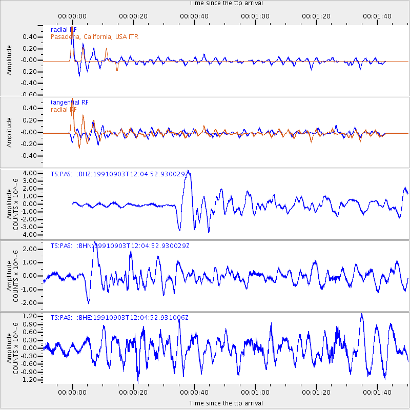
Signal To Noise
| Channel | StoN | STA | LTA |
| TS:PAS: :BHN:19910903T12:04:52.930029Z | 2.3486235 | 3.9046765E-7 | 1.6625384E-7 |
| TS:PAS: :BHE:19910903T12:04:52.931006Z | 1.1712662 | 1.6491622E-7 | 1.4080165E-7 |
| TS:PAS: :BHZ:19910903T12:04:52.930029Z | 4.2165704 | 7.4357587E-7 | 1.7634612E-7 |
| Arrivals |
| Ps | 3.6 SECOND |
| PpPs | 11 SECOND |
| PsPs/PpSs | 15 SECOND |


