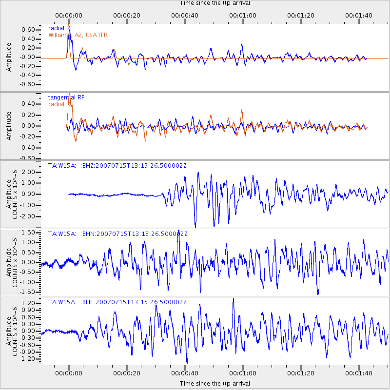
W15A Williams, AZ, USA - Earthquake Result Viewer
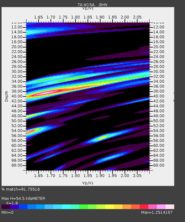
Earthquake location: Fox Islands, Aleutian Islands
Earthquake latitude/longitude: 52.5/-168.0
Earthquake time(UTC): 2007/07/15 (196) 13:08:00 GMT
Earthquake Depth: 10 km
Earthquake Magnitude: 5.8 MB, 5.9 MS, 6.1 MW, 6.0 MW
Earthquake Catalog/Contributor: WHDF/NEIC
Network: TA USArray Transportable Network (new EarthScope stations)
Station: W15A Williams, AZ, USA
Lat/Lon: 35.18 N/112.27 W
Elevation: 2034 m
Distance: 42.6 deg
Az: 91.156 deg
Baz: 311.713 deg
Ray Param: 0.07305238
Estimated Moho Depth: 54.5 km
Estimated Crust Vp/Vs: 1.60
Assumed Crust Vp: 6.276 km/s
Estimated Crust Vs: 3.922 km/s
Estimated Crust Poisson's Ratio: 0.18
Radial Match: 91.75516 %
Radial Bump: 400
Transverse Match: 84.86163 %
Transverse Bump: 400
SOD ConfigId: 2564
Insert Time: 2010-03-07 05:55:49.152 +0000
GWidth: 2.5
Max Bumps: 400
Tol: 0.001

Signal To Noise

ChannelStoNSTALTA
TA:W15A: :BHN:20070715T13:15:26.500002Z2.45008441.9341886E-77.894375E-8
TA:W15A: :BHE:20070715T13:15:26.500002Z2.35437081.3621369E-75.785566E-8
TA:W15A: :BHZ:20070715T13:15:26.500002Z5.08080343.2796245E-76.4549326E-8
Arrivals
Ps5.6 SECOND
PpPs21 SECOND
PsPs/PpSs27 SECOND