You are here: Home > Network List > TA - USArray Transportable Network (new EarthScope stations) Stations List
> Station W15A Williams, AZ, USA > Earthquake Result Viewer
W15A Williams, AZ, USA - Earthquake Result Viewer
| Earthquake location: |
Near West Coast Of Colombia |
| Earthquake latitude/longitude: |
3.0/-78.0 |
| Earthquake time(UTC): |
2007/09/10 (253) 01:49:14 GMT |
| Earthquake Depth: |
31 km |
| Earthquake Magnitude: |
6.1 MB, 6.7 MS, 6.8 MW |
| Earthquake Catalog/Contributor: |
WHDF/NEIC |
|
| Network: |
TA USArray Transportable Network (new EarthScope stations) |
| Station: |
W15A Williams, AZ, USA |
| Lat/Lon: |
35.18 N/112.27 W |
| Elevation: |
2034 m |
|
| Distance: |
45.1 deg |
| Az: |
319.359 deg |
| Baz: |
127.437 deg |
| Ray Param: |
0.07141737 |
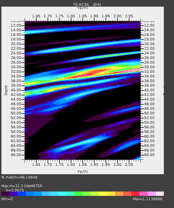
| Estimated Moho Depth: |
31.0 km |
| Estimated Crust Vp/Vs: |
2.09 |
| Assumed Crust Vp: |
6.276 km/s |
| Estimated Crust Vs: |
3.006 km/s |
| Estimated Crust Poisson's Ratio: |
0.35 |
|
| Radial Match: |
96.18946 % |
| Radial Bump: |
400 |
| Transverse Match: |
88.76672 % |
| Transverse Bump: |
400 |
| SOD ConfigId: |
2564 |
| Insert Time: |
2010-03-07 05:56:02.989 +0000 |
| GWidth: |
2.5 |
| Max Bumps: |
400 |
| Tol: |
0.001 |
|
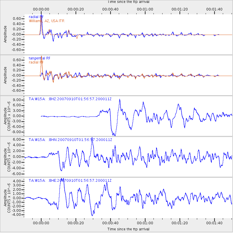
Signal To Noise
| Channel | StoN | STA | LTA |
| TA:W15A: :BHN:20070910T01:56:57.200011Z | 3.624777 | 3.8618526E-7 | 1.0654042E-7 |
| TA:W15A: :BHE:20070910T01:56:57.200011Z | 3.394372 | 4.7342834E-7 | 1.3947451E-7 |
| TA:W15A: :BHZ:20070910T01:56:57.200011Z | 8.427433 | 1.1683538E-6 | 1.3863698E-7 |
| Arrivals |
| Ps | 5.7 SECOND |
| PpPs | 14 SECOND |
| PsPs/PpSs | 20 SECOND |


