You are here: Home > Network List > II - Global Seismograph Network (GSN - IRIS/IDA) Stations List
> Station WRAB Tennant Creek, NT, Australia > Earthquake Result Viewer
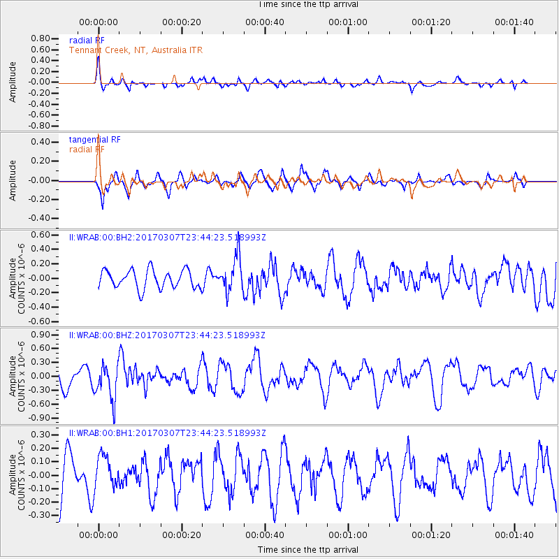
WRAB Tennant Creek, NT, Australia - Earthquake Result Viewer
*The percent match for this event was below the threshold and hence no stack was calculated.
| Earthquake location: |
Vanuatu Islands |
| Earthquake latitude/longitude: |
-15.0/168.2 |
| Earthquake time(UTC): |
2017/03/07 (066) 23:38:22 GMT |
| Earthquake Depth: |
8.0 km |
| Earthquake Magnitude: |
5.6 Mww |
| Earthquake Catalog/Contributor: |
NEIC PDE/us |
|
| Network: |
II Global Seismograph Network (GSN - IRIS/IDA) |
| Station: |
WRAB Tennant Creek, NT, Australia |
| Lat/Lon: |
19.93 S/134.36 E |
| Elevation: |
366 m |
|
| Distance: |
32.6 deg |
| Az: |
256.455 deg |
| Baz: |
86.83 deg |
| Ray Param: |
$rayparam |
*The percent match for this event was below the threshold and hence was not used in the summary stack. |
|
| Radial Match: |
62.436634 % |
| Radial Bump: |
400 |
| Transverse Match: |
62.486633 % |
| Transverse Bump: |
351 |
| SOD ConfigId: |
1992691 |
| Insert Time: |
2017-03-21 23:39:48.494 +0000 |
| GWidth: |
2.5 |
| Max Bumps: |
400 |
| Tol: |
0.001 |
|
Signal To Noise
| Channel | StoN | STA | LTA |
| II:WRAB:00:BHZ:20170307T23:44:23.518993Z | 1.7010555 | 3.8746546E-7 | 2.2777942E-7 |
| II:WRAB:00:BH1:20170307T23:44:23.518993Z | 0.5688299 | 1.17742424E-7 | 2.0699058E-7 |
| II:WRAB:00:BH2:20170307T23:44:23.518993Z | 1.9988362 | 2.5175032E-7 | 1.2594846E-7 |
| Arrivals |
| Ps | |
| PpPs | |
| PsPs/PpSs | |


