You are here: Home > Network List > TA - USArray Transportable Network (new EarthScope stations) Stations List
> Station W15A Williams, AZ, USA > Earthquake Result Viewer
W15A Williams, AZ, USA - Earthquake Result Viewer
| Earthquake location: |
Tonga Islands |
| Earthquake latitude/longitude: |
-20.7/-175.5 |
| Earthquake time(UTC): |
2007/02/05 (036) 10:16:24 GMT |
| Earthquake Depth: |
15 km |
| Earthquake Magnitude: |
5.6 MB, 5.4 MS |
| Earthquake Catalog/Contributor: |
WHDF/NEIC |
|
| Network: |
TA USArray Transportable Network (new EarthScope stations) |
| Station: |
W15A Williams, AZ, USA |
| Lat/Lon: |
35.18 N/112.27 W |
| Elevation: |
2034 m |
|
| Distance: |
81.7 deg |
| Az: |
47.65 deg |
| Baz: |
237.647 deg |
| Ray Param: |
0.0473895 |
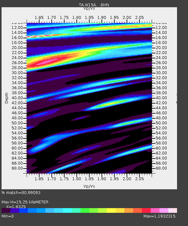
| Estimated Moho Depth: |
15.25 km |
| Estimated Crust Vp/Vs: |
1.63 |
| Assumed Crust Vp: |
6.276 km/s |
| Estimated Crust Vs: |
3.844 km/s |
| Estimated Crust Poisson's Ratio: |
0.20 |
|
| Radial Match: |
80.99093 % |
| Radial Bump: |
400 |
| Transverse Match: |
59.728035 % |
| Transverse Bump: |
400 |
| SOD ConfigId: |
2564 |
| Insert Time: |
2010-03-07 05:56:10.586 +0000 |
| GWidth: |
2.5 |
| Max Bumps: |
400 |
| Tol: |
0.001 |
|

Signal To Noise
| Channel | StoN | STA | LTA |
| TA:W15A: :BHN:20070205T10:28:10.50002Z | 1.8508542 | 5.3495177E-7 | 2.8902966E-7 |
| TA:W15A: :BHE:20070205T10:28:10.50002Z | 1.9647423 | 4.0902208E-7 | 2.0818104E-7 |
| TA:W15A: :BHZ:20070205T10:28:10.50002Z | 3.497814 | 4.7336817E-7 | 1.3533258E-7 |
| Arrivals |
| Ps | 1.6 SECOND |
| PpPs | 6.2 SECOND |
| PsPs/PpSs | 7.8 SECOND |


