You are here: Home > Network List > TA - USArray Transportable Network (new EarthScope stations) Stations List
> Station W15A Williams, AZ, USA > Earthquake Result Viewer
W15A Williams, AZ, USA - Earthquake Result Viewer
| Earthquake location: |
Eastern Siberia, Russia |
| Earthquake latitude/longitude: |
60.5/167.5 |
| Earthquake time(UTC): |
2006/04/29 (119) 16:58:06 GMT |
| Earthquake Depth: |
11 km |
| Earthquake Magnitude: |
6.4 MB, 6.6 MS, 6.6 MW, 6.4 MW |
| Earthquake Catalog/Contributor: |
WHDF/NEIC |
|
| Network: |
TA USArray Transportable Network (new EarthScope stations) |
| Station: |
W15A Williams, AZ, USA |
| Lat/Lon: |
35.18 N/112.27 W |
| Elevation: |
2034 m |
|
| Distance: |
55.4 deg |
| Az: |
78.584 deg |
| Baz: |
323.673 deg |
| Ray Param: |
0.06478786 |
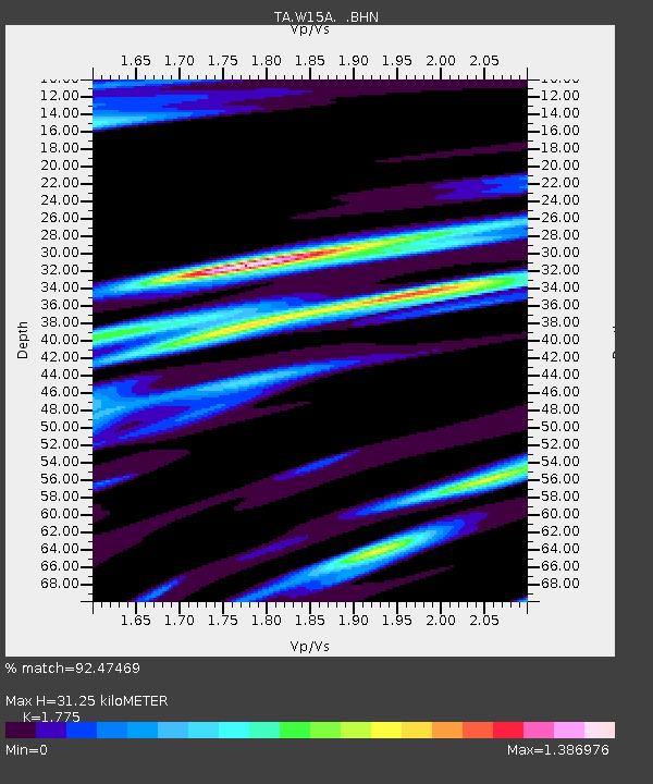
| Estimated Moho Depth: |
31.25 km |
| Estimated Crust Vp/Vs: |
1.77 |
| Assumed Crust Vp: |
6.276 km/s |
| Estimated Crust Vs: |
3.536 km/s |
| Estimated Crust Poisson's Ratio: |
0.27 |
|
| Radial Match: |
92.47469 % |
| Radial Bump: |
400 |
| Transverse Match: |
80.526924 % |
| Transverse Bump: |
400 |
| SOD ConfigId: |
2669 |
| Insert Time: |
2010-03-07 05:56:15.427 +0000 |
| GWidth: |
2.5 |
| Max Bumps: |
400 |
| Tol: |
0.001 |
|

Signal To Noise
| Channel | StoN | STA | LTA |
| TA:W15A: :BHN:20060429T17:07:09.725029Z | 3.876751 | 3.9268406E-7 | 1.0129205E-7 |
| TA:W15A: :BHE:20060429T17:07:09.725029Z | 3.1700344 | 1.7570642E-7 | 5.5427293E-8 |
| TA:W15A: :BHZ:20060429T17:07:09.725029Z | 7.549906 | 6.2970815E-7 | 8.340609E-8 |
| Arrivals |
| Ps | 4.1 SECOND |
| PpPs | 13 SECOND |
| PsPs/PpSs | 17 SECOND |


