You are here: Home > Network List > TA - USArray Transportable Network (new EarthScope stations) Stations List
> Station W15A Williams, AZ, USA > Earthquake Result Viewer
W15A Williams, AZ, USA - Earthquake Result Viewer
| Earthquake location: |
Eastern Siberia, Russia |
| Earthquake latitude/longitude: |
61.6/168.6 |
| Earthquake time(UTC): |
2006/09/06 (249) 05:00:28 GMT |
| Earthquake Depth: |
10 km |
| Earthquake Magnitude: |
5.5 MB, 5.0 MS, 5.4 MW, 5.3 MW |
| Earthquake Catalog/Contributor: |
WHDF/NEIC |
|
| Network: |
TA USArray Transportable Network (new EarthScope stations) |
| Station: |
W15A Williams, AZ, USA |
| Lat/Lon: |
35.18 N/112.27 W |
| Elevation: |
2034 m |
|
| Distance: |
54.7 deg |
| Az: |
80.279 deg |
| Baz: |
324.921 deg |
| Ray Param: |
0.06528662 |
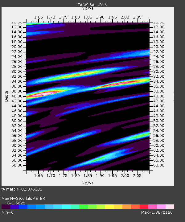
| Estimated Moho Depth: |
39.0 km |
| Estimated Crust Vp/Vs: |
1.66 |
| Assumed Crust Vp: |
6.276 km/s |
| Estimated Crust Vs: |
3.775 km/s |
| Estimated Crust Poisson's Ratio: |
0.22 |
|
| Radial Match: |
82.076385 % |
| Radial Bump: |
400 |
| Transverse Match: |
76.5412 % |
| Transverse Bump: |
400 |
| SOD ConfigId: |
2564 |
| Insert Time: |
2010-03-07 05:56:26.022 +0000 |
| GWidth: |
2.5 |
| Max Bumps: |
400 |
| Tol: |
0.001 |
|
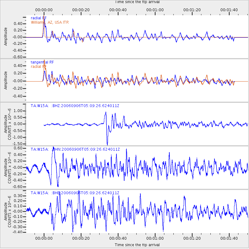
Signal To Noise
| Channel | StoN | STA | LTA |
| TA:W15A: :BHN:20060906T05:09:26.624011Z | 4.0499578 | 2.523419E-7 | 6.2307286E-8 |
| TA:W15A: :BHE:20060906T05:09:26.624011Z | 1.6974841 | 7.778332E-8 | 4.582271E-8 |
| TA:W15A: :BHZ:20060906T05:09:26.624011Z | 13.287121 | 5.792078E-7 | 4.3591672E-8 |
| Arrivals |
| Ps | 4.3 SECOND |
| PpPs | 16 SECOND |
| PsPs/PpSs | 20 SECOND |


