You are here: Home > Network List > MM - Myanmar National Seismic Network Stations List
> Station NGU Ngaung U, Myanmar > Earthquake Result Viewer
NGU Ngaung U, Myanmar - Earthquake Result Viewer
| Earthquake location: |
Mindanao, Philippines |
| Earthquake latitude/longitude: |
7.6/125.0 |
| Earthquake time(UTC): |
2019/11/18 (322) 13:22:12 GMT |
| Earthquake Depth: |
26 km |
| Earthquake Magnitude: |
5.9 Mww |
| Earthquake Catalog/Contributor: |
NEIC PDE/us |
|
| Network: |
MM Myanmar National Seismic Network |
| Station: |
NGU Ngaung U, Myanmar |
| Lat/Lon: |
21.21 N/94.92 E |
| Elevation: |
70 m |
|
| Distance: |
32.0 deg |
| Az: |
298.149 deg |
| Baz: |
110.493 deg |
| Ray Param: |
0.07879384 |
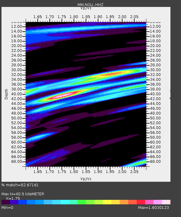
| Estimated Moho Depth: |
40.5 km |
| Estimated Crust Vp/Vs: |
1.75 |
| Assumed Crust Vp: |
6.036 km/s |
| Estimated Crust Vs: |
3.449 km/s |
| Estimated Crust Poisson's Ratio: |
0.26 |
|
| Radial Match: |
82.67161 % |
| Radial Bump: |
400 |
| Transverse Match: |
63.79099 % |
| Transverse Bump: |
400 |
| SOD ConfigId: |
19951751 |
| Insert Time: |
2019-12-02 13:28:36.189 +0000 |
| GWidth: |
2.5 |
| Max Bumps: |
400 |
| Tol: |
0.001 |
|

Signal To Noise
| Channel | StoN | STA | LTA |
| MM:NGU: :HHZ:20191118T13:28:05.810004Z | 7.5141077 | 1.2419262E-6 | 1.6527926E-7 |
| MM:NGU: :HHN:20191118T13:28:05.810004Z | 1.6771832 | 2.1429805E-7 | 1.2777261E-7 |
| MM:NGU: :HHE:20191118T13:28:05.810004Z | 1.0483034 | 2.5974109E-7 | 2.4777282E-7 |
| Arrivals |
| Ps | 5.4 SECOND |
| PpPs | 17 SECOND |
| PsPs/PpSs | 23 SECOND |


