You are here: Home > Network List > TS - TERRAscope (Southern California Seismic Network) Stations List
> Station PAS Pasadena, California, USA > Earthquake Result Viewer
PAS Pasadena, California, USA - Earthquake Result Viewer
| Earthquake location: |
Andreanof Islands, Aleutian Is. |
| Earthquake latitude/longitude: |
52.5/-178.9 |
| Earthquake time(UTC): |
1992/03/13 (073) 16:01:06 GMT |
| Earthquake Depth: |
211 km |
| Earthquake Magnitude: |
6.0 MB, 6.3 UNKNOWN |
| Earthquake Catalog/Contributor: |
WHDF/NEIC |
|
| Network: |
TS TERRAscope (Southern California Seismic Network) |
| Station: |
PAS Pasadena, California, USA |
| Lat/Lon: |
34.15 N/118.17 W |
| Elevation: |
295 m |
|
| Distance: |
46.4 deg |
| Az: |
88.318 deg |
| Baz: |
312.509 deg |
| Ray Param: |
0.06986223 |
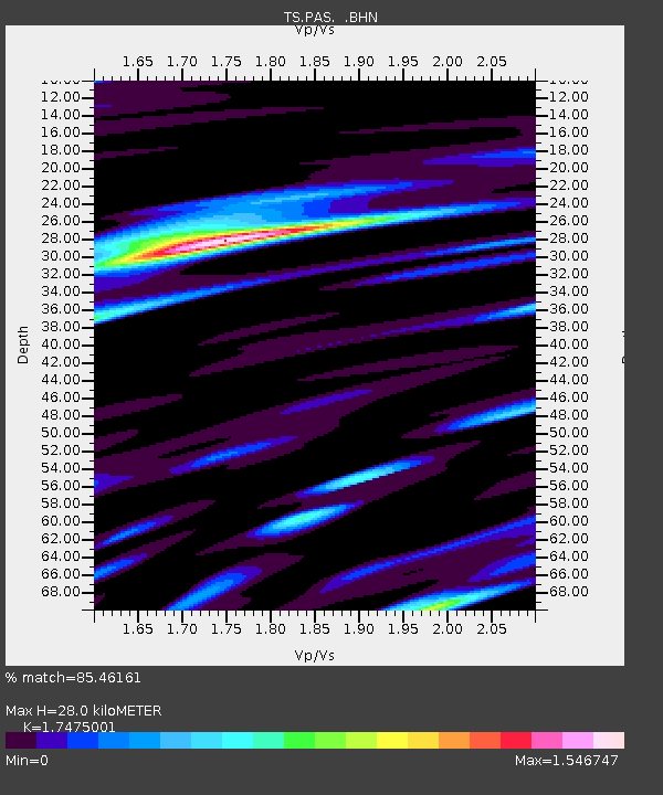
| Estimated Moho Depth: |
28.0 km |
| Estimated Crust Vp/Vs: |
1.75 |
| Assumed Crust Vp: |
6.1 km/s |
| Estimated Crust Vs: |
3.491 km/s |
| Estimated Crust Poisson's Ratio: |
0.26 |
|
| Radial Match: |
85.46161 % |
| Radial Bump: |
400 |
| Transverse Match: |
84.521454 % |
| Transverse Bump: |
400 |
| SOD ConfigId: |
16938 |
| Insert Time: |
2010-02-26 14:34:37.231 +0000 |
| GWidth: |
2.5 |
| Max Bumps: |
400 |
| Tol: |
0.001 |
|
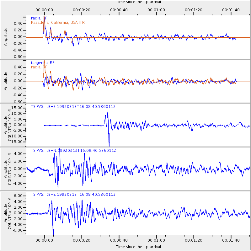
Signal To Noise
| Channel | StoN | STA | LTA |
| TS:PAS: :BHN:19920313T16:08:40.536011Z | 3.0720525 | 8.9028333E-7 | 2.8980082E-7 |
| TS:PAS: :BHE:19920313T16:08:40.536011Z | 15.728147 | 2.2895256E-6 | 1.4556868E-7 |
| TS:PAS: :BHZ:19920313T16:08:40.536011Z | 21.904856 | 5.8725072E-6 | 2.6809158E-7 |
| Arrivals |
| Ps | 3.6 SECOND |
| PpPs | 12 SECOND |
| PsPs/PpSs | 16 SECOND |


