You are here: Home > Network List > TA - USArray Transportable Network (new EarthScope stations) Stations List
> Station W15A Williams, AZ, USA > Earthquake Result Viewer
W15A Williams, AZ, USA - Earthquake Result Viewer

| Earthquake location: |
Kuril Islands |
| Earthquake latitude/longitude: |
46.5/153.4 |
| Earthquake time(UTC): |
2006/09/28 (271) 01:36:48 GMT |
| Earthquake Depth: |
11 km |
| Earthquake Magnitude: |
5.8 MB, 5.5 MS, 5.9 MW, 5.9 MW |
| Earthquake Catalog/Contributor: |
WHDF/NEIC |
|
| Network: |
TA USArray Transportable Network (new EarthScope stations) |
| Station: |
W15A Williams, AZ, USA |
| Lat/Lon: |
35.18 N/112.27 W |
| Elevation: |
2034 m |
|
| Distance: |
68.2 deg |
| Az: |
61.602 deg |
| Baz: |
312.072 deg |
| Ray Param: |
0.056453254 |
| Estimated Moho Depth: |
38.0 km |
| Estimated Crust Vp/Vs: |
1.63 |
| Assumed Crust Vp: |
6.276 km/s |
| Estimated Crust Vs: |
3.844 km/s |
| Estimated Crust Poisson's Ratio: |
0.20 |
|
| Radial Match: |
83.22116 % |
| Radial Bump: |
400 |
| Transverse Match: |
71.95419 % |
| Transverse Bump: |
400 |
| SOD ConfigId: |
2665 |
| Insert Time: |
2010-03-07 05:56:40.632 +0000 |
| GWidth: |
2.5 |
| Max Bumps: |
400 |
| Tol: |
0.001 |
|
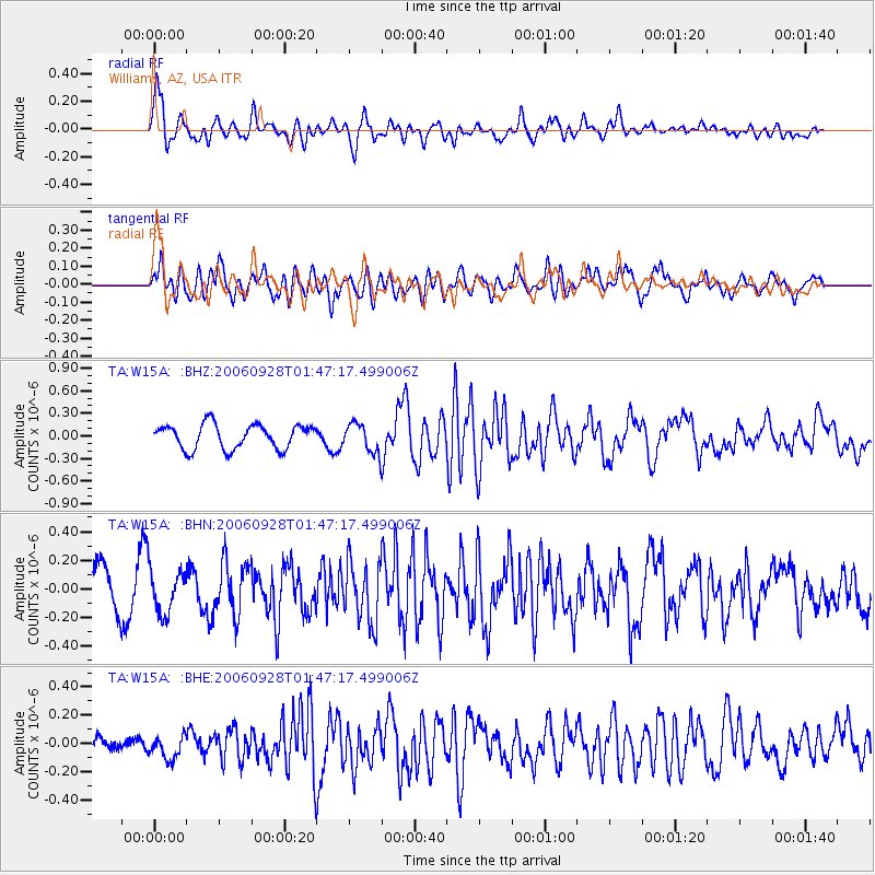
Signal To Noise
| Channel | StoN | STA | LTA |
| TA:W15A: :BHN:20060928T01:47:17.499006Z | 0.9980321 | 1.5079962E-7 | 1.5109697E-7 |
| TA:W15A: :BHE:20060928T01:47:17.499006Z | 0.98163426 | 8.2492534E-8 | 8.403592E-8 |
| TA:W15A: :BHZ:20060928T01:47:17.499006Z | 1.2453154 | 1.9972292E-7 | 1.6037939E-7 |
| Arrivals |
| Ps | 4.0 SECOND |
| PpPs | 15 SECOND |
| PsPs/PpSs | 19 SECOND |


