You are here: Home > Network List > TA - USArray Transportable Network (new EarthScope stations) Stations List
> Station E20K Nigu River, AK, USA > Earthquake Result Viewer
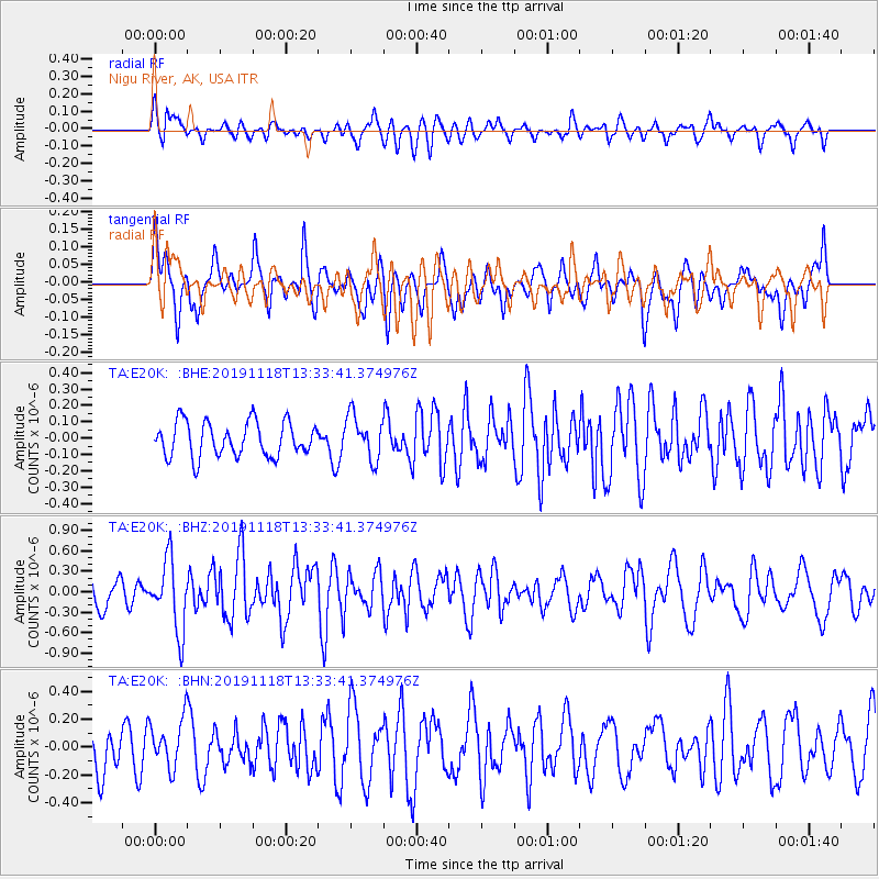
E20K Nigu River, AK, USA - Earthquake Result Viewer
*The percent match for this event was below the threshold and hence no stack was calculated.
| Earthquake location: |
Mindanao, Philippines |
| Earthquake latitude/longitude: |
7.6/125.0 |
| Earthquake time(UTC): |
2019/11/18 (322) 13:22:12 GMT |
| Earthquake Depth: |
26 km |
| Earthquake Magnitude: |
5.9 Mww |
| Earthquake Catalog/Contributor: |
NEIC PDE/us |
|
| Network: |
TA USArray Transportable Network (new EarthScope stations) |
| Station: |
E20K Nigu River, AK, USA |
| Lat/Lon: |
68.26 N/156.19 W |
| Elevation: |
866 m |
|
| Distance: |
78.8 deg |
| Az: |
21.875 deg |
| Baz: |
262.427 deg |
| Ray Param: |
$rayparam |
*The percent match for this event was below the threshold and hence was not used in the summary stack. |
|
| Radial Match: |
67.34994 % |
| Radial Bump: |
400 |
| Transverse Match: |
56.825253 % |
| Transverse Bump: |
400 |
| SOD ConfigId: |
19951751 |
| Insert Time: |
2019-12-02 13:29:26.345 +0000 |
| GWidth: |
2.5 |
| Max Bumps: |
400 |
| Tol: |
0.001 |
|
Signal To Noise
| Channel | StoN | STA | LTA |
| TA:E20K: :BHZ:20191118T13:33:41.374976Z | 2.0134287 | 5.1882125E-7 | 2.5768048E-7 |
| TA:E20K: :BHN:20191118T13:33:41.374976Z | 0.9211343 | 1.7454492E-7 | 1.8948913E-7 |
| TA:E20K: :BHE:20191118T13:33:41.374976Z | 1.2837718 | 1.3445433E-7 | 1.0473382E-7 |
| Arrivals |
| Ps | |
| PpPs | |
| PsPs/PpSs | |


