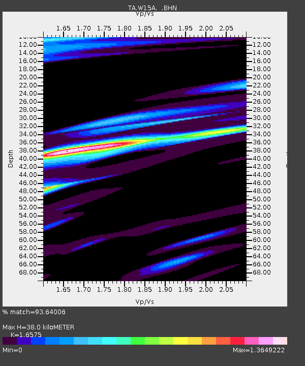
W15A Williams, AZ, USA - Earthquake Result Viewer
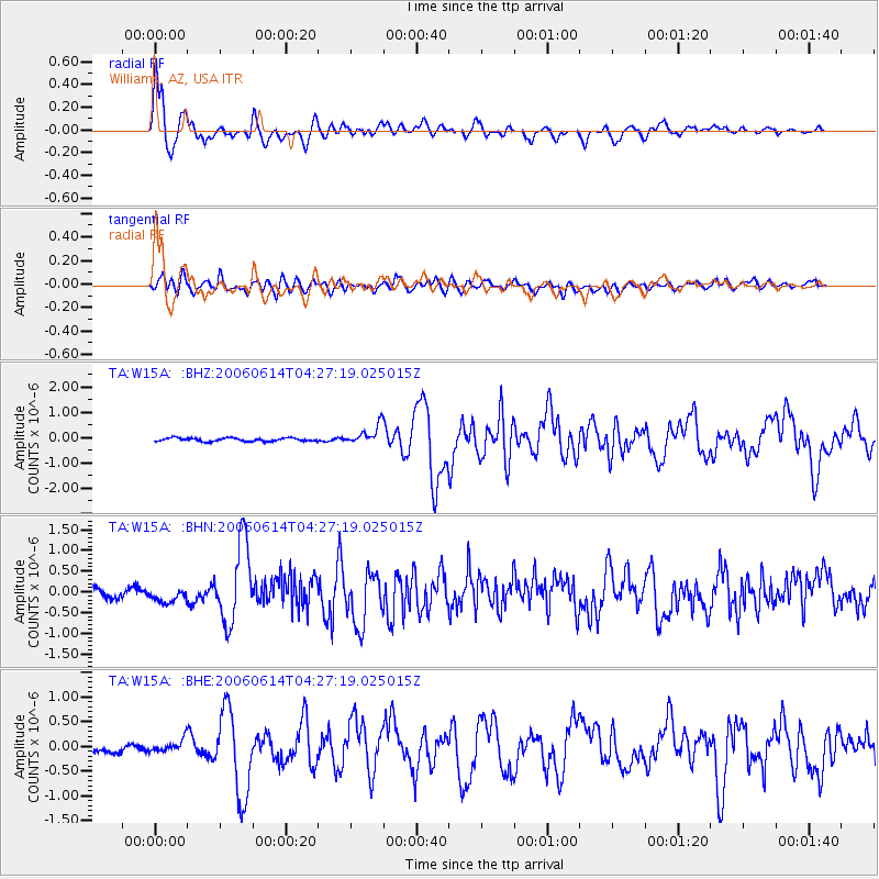
Earthquake location: Rat Islands, Aleutian Islands
Earthquake latitude/longitude: 51.8/177.1
Earthquake time(UTC): 2006/06/14 (165) 04:18:42 GMT
Earthquake Depth: 14 km
Earthquake Magnitude: 5.9 MB, 6.4 MS, 6.4 MW, 6.4 MW
Earthquake Catalog/Contributor: WHDF/NEIC
Network: TA USArray Transportable Network (new EarthScope stations)
Station: W15A Williams, AZ, USA
Lat/Lon: 35.18 N/112.27 W
Elevation: 2034 m
Distance: 51.8 deg
Az: 79.451 deg
Baz: 311.753 deg
Ray Param: 0.06714479
Estimated Moho Depth: 38.0 km
Estimated Crust Vp/Vs: 1.66
Assumed Crust Vp: 6.276 km/s
Estimated Crust Vs: 3.786 km/s
Estimated Crust Poisson's Ratio: 0.21
Radial Match: 93.64006 %
Radial Bump: 400
Transverse Match: 71.36718 %
Transverse Bump: 400
SOD ConfigId: 5745
Insert Time: 2010-03-07 05:56:53.314 +0000
GWidth: 2.5
Max Bumps: 400
Tol: 0.001

Signal To Noise

ChannelStoNSTALTA
TA:W15A: :BHN:20060614T04:27:19.025015Z1.36187271.7394314E-71.277235E-7
TA:W15A: :BHE:20060614T04:27:19.025015Z1.51684521.2666811E-78.350761E-8
TA:W15A: :BHZ:20060614T04:27:19.025015Z5.81754833.7901358E-76.5150054E-8
Arrivals
Ps4.2 SECOND
PpPs15 SECOND
PsPs/PpSs19 SECOND