You are here: Home > Network List > TA - USArray Transportable Network (new EarthScope stations) Stations List
> Station W15A Williams, AZ, USA > Earthquake Result Viewer
W15A Williams, AZ, USA - Earthquake Result Viewer
| Earthquake location: |
Tonga Islands |
| Earthquake latitude/longitude: |
-20.6/-173.9 |
| Earthquake time(UTC): |
2006/05/17 (137) 03:06:16 GMT |
| Earthquake Depth: |
10 km |
| Earthquake Magnitude: |
5.8 MB, 5.8 MS, 6.0 MW, 5.8 MW |
| Earthquake Catalog/Contributor: |
WHDF/NEIC |
|
| Network: |
TA USArray Transportable Network (new EarthScope stations) |
| Station: |
W15A Williams, AZ, USA |
| Lat/Lon: |
35.18 N/112.27 W |
| Elevation: |
2034 m |
|
| Distance: |
80.6 deg |
| Az: |
46.964 deg |
| Baz: |
236.69 deg |
| Ray Param: |
0.04815303 |
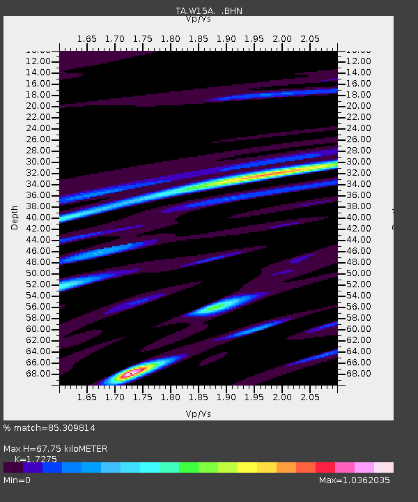
| Estimated Moho Depth: |
67.75 km |
| Estimated Crust Vp/Vs: |
1.73 |
| Assumed Crust Vp: |
6.276 km/s |
| Estimated Crust Vs: |
3.633 km/s |
| Estimated Crust Poisson's Ratio: |
0.25 |
|
| Radial Match: |
85.309814 % |
| Radial Bump: |
400 |
| Transverse Match: |
79.06852 % |
| Transverse Bump: |
400 |
| SOD ConfigId: |
2669 |
| Insert Time: |
2010-03-07 05:56:56.500 +0000 |
| GWidth: |
2.5 |
| Max Bumps: |
400 |
| Tol: |
0.001 |
|

Signal To Noise
| Channel | StoN | STA | LTA |
| TA:W15A: :BHN:20060517T03:17:57.523018Z | 1.9501605 | 1.8653975E-7 | 9.565354E-8 |
| TA:W15A: :BHE:20060517T03:17:57.523018Z | 1.6203786 | 1.3954683E-7 | 8.611988E-8 |
| TA:W15A: :BHZ:20060517T03:17:57.523018Z | 4.4741325 | 3.7621655E-7 | 8.4087034E-8 |
| Arrivals |
| Ps | 8.1 SECOND |
| PpPs | 29 SECOND |
| PsPs/PpSs | 37 SECOND |


