You are here: Home > Network List > TA - USArray Transportable Network (new EarthScope stations) Stations List
> Station W15A Williams, AZ, USA > Earthquake Result Viewer
W15A Williams, AZ, USA - Earthquake Result Viewer
| Earthquake location: |
Chile-Bolivia Border Region |
| Earthquake latitude/longitude: |
-20.0/-69.0 |
| Earthquake time(UTC): |
2008/03/24 (084) 20:39:07 GMT |
| Earthquake Depth: |
120 km |
| Earthquake Magnitude: |
5.7 MB, 6.2 MW, 6.1 MW |
| Earthquake Catalog/Contributor: |
WHDF/NEIC |
|
| Network: |
TA USArray Transportable Network (new EarthScope stations) |
| Station: |
W15A Williams, AZ, USA |
| Lat/Lon: |
35.18 N/112.27 W |
| Elevation: |
2034 m |
|
| Distance: |
68.6 deg |
| Az: |
322.879 deg |
| Baz: |
136.161 deg |
| Ray Param: |
0.0558917 |
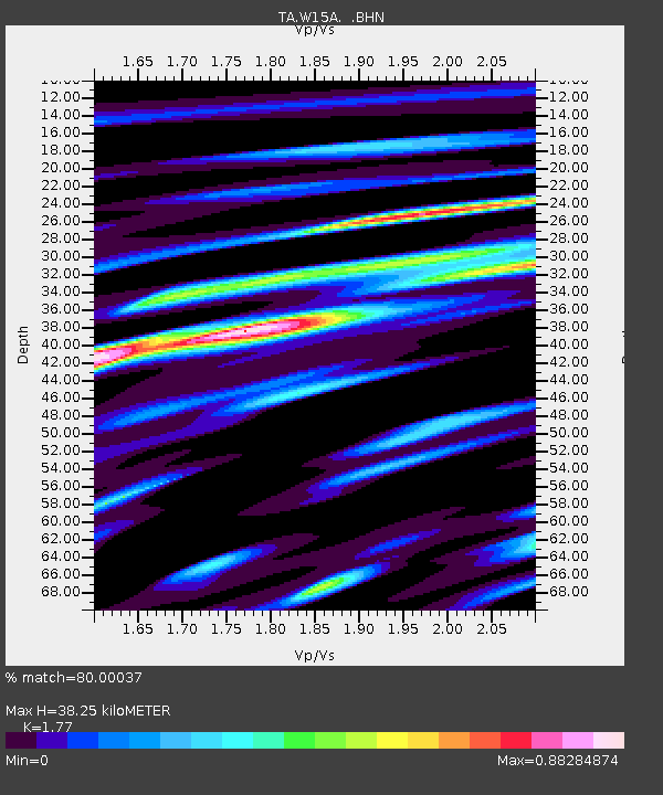
| Estimated Moho Depth: |
38.25 km |
| Estimated Crust Vp/Vs: |
1.77 |
| Assumed Crust Vp: |
6.276 km/s |
| Estimated Crust Vs: |
3.546 km/s |
| Estimated Crust Poisson's Ratio: |
0.27 |
|
| Radial Match: |
80.00037 % |
| Radial Bump: |
400 |
| Transverse Match: |
57.56146 % |
| Transverse Bump: |
400 |
| SOD ConfigId: |
2564 |
| Insert Time: |
2010-03-07 05:57:01.763 +0000 |
| GWidth: |
2.5 |
| Max Bumps: |
400 |
| Tol: |
0.001 |
|
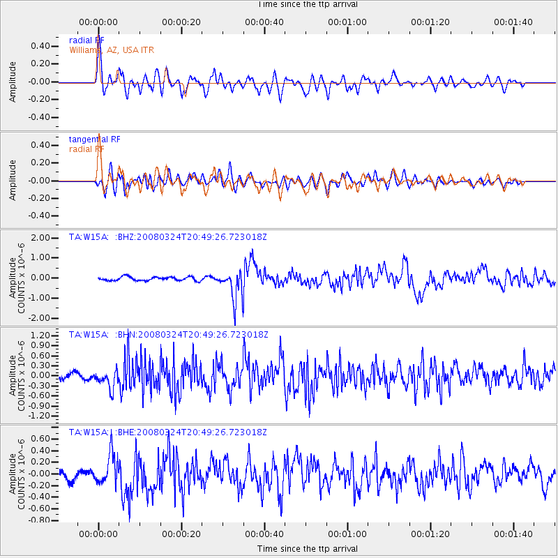
Signal To Noise
| Channel | StoN | STA | LTA |
| TA:W15A: :BHN:20080324T20:49:26.723018Z | 3.0547123 | 2.8139252E-7 | 9.211752E-8 |
| TA:W15A: :BHE:20080324T20:49:26.723018Z | 2.5811577 | 2.5508606E-7 | 9.882623E-8 |
| TA:W15A: :BHZ:20080324T20:49:26.723018Z | 8.2335615 | 7.6827206E-7 | 9.330981E-8 |
| Arrivals |
| Ps | 4.9 SECOND |
| PpPs | 16 SECOND |
| PsPs/PpSs | 21 SECOND |


