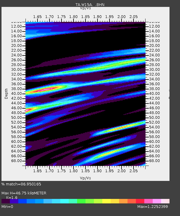
W15A Williams, AZ, USA - Earthquake Result Viewer
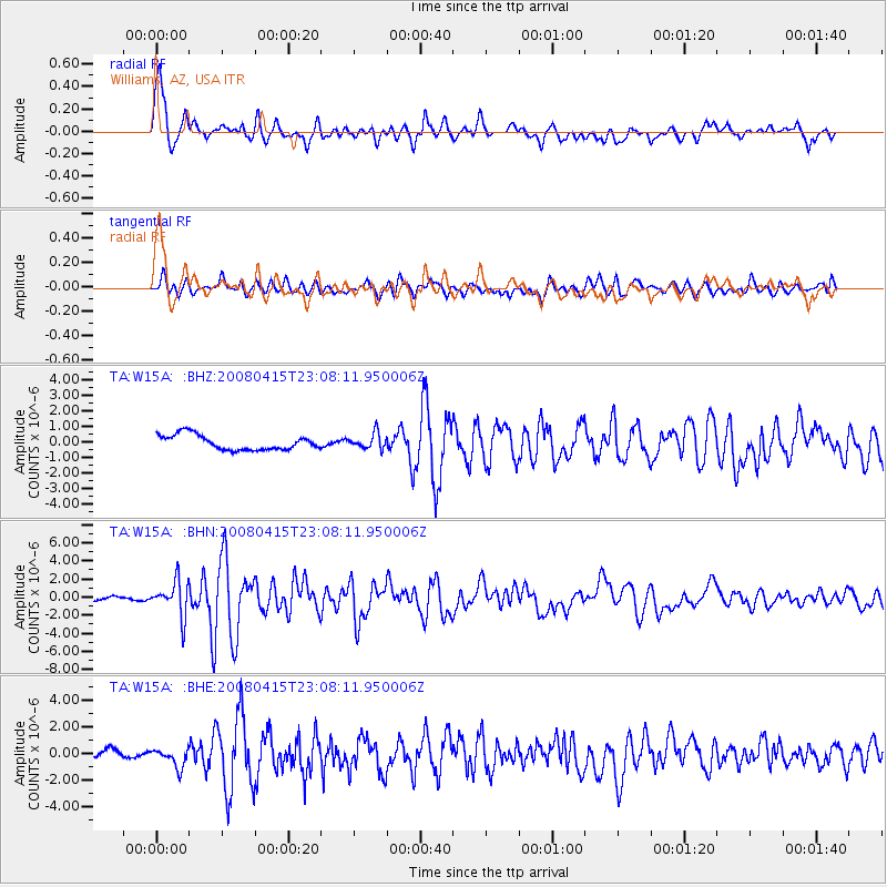
Earthquake location: Andreanof Islands, Aleutian Is.
Earthquake latitude/longitude: 51.9/-179.4
Earthquake time(UTC): 2008/04/15 (106) 22:59:51 GMT
Earthquake Depth: 10 km
Earthquake Magnitude: 6.1 MB, 6.4 MS, 6.4 MW, 6.4 MW
Earthquake Catalog/Contributor: WHDF/NEIC
Network: TA USArray Transportable Network (new EarthScope stations)
Station: W15A Williams, AZ, USA
Lat/Lon: 35.18 N/112.27 W
Elevation: 2034 m
Distance: 49.6 deg
Az: 82.033 deg
Baz: 311.424 deg
Ray Param: 0.06857606
Estimated Moho Depth: 46.75 km
Estimated Crust Vp/Vs: 1.60
Assumed Crust Vp: 6.276 km/s
Estimated Crust Vs: 3.922 km/s
Estimated Crust Poisson's Ratio: 0.18
Radial Match: 86.950165 %
Radial Bump: 400
Transverse Match: 67.451515 %
Transverse Bump: 400
SOD ConfigId: 2504
Insert Time: 2010-03-07 05:57:08.212 +0000
GWidth: 2.5
Max Bumps: 400
Tol: 0.001

Signal To Noise

ChannelStoNSTALTA
TA:W15A: :BHN:20080415T23:08:11.950006Z9.7208231.9208462E-61.9760118E-7
TA:W15A: :BHE:20080415T23:08:11.950006Z2.32897456.9610206E-72.988878E-7
TA:W15A: :BHZ:20080415T23:08:11.950006Z1.03998514.9257375E-74.7363542E-7
Arrivals
Ps4.8 SECOND
PpPs18 SECOND
PsPs/PpSs23 SECOND