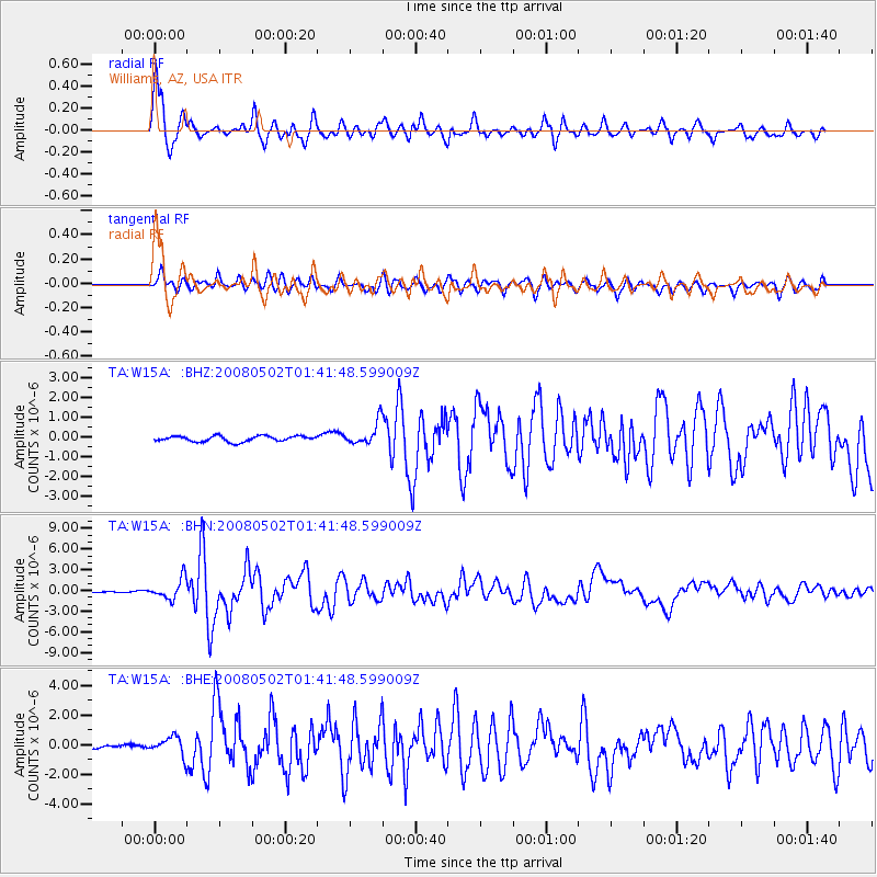
W15A Williams, AZ, USA - Earthquake Result Viewer
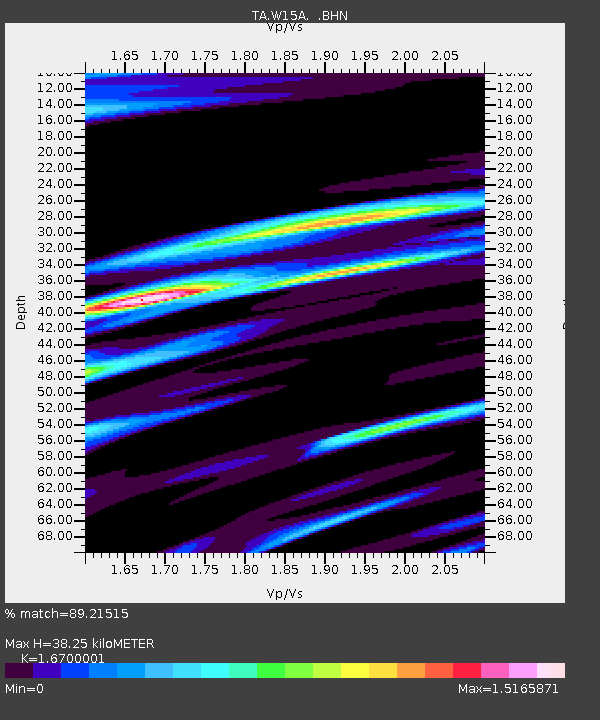
Earthquake location: Andreanof Islands, Aleutian Is.
Earthquake latitude/longitude: 51.9/-177.5
Earthquake time(UTC): 2008/05/02 (123) 01:33:37 GMT
Earthquake Depth: 14 km
Earthquake Magnitude: 6.3 MB, 6.8 MS, 6.6 MW, 6.6 MW
Earthquake Catalog/Contributor: WHDF/NEIC
Network: TA USArray Transportable Network (new EarthScope stations)
Station: W15A Williams, AZ, USA
Lat/Lon: 35.18 N/112.27 W
Elevation: 2034 m
Distance: 48.5 deg
Az: 83.352 deg
Baz: 311.246 deg
Ray Param: 0.0693058
Estimated Moho Depth: 38.25 km
Estimated Crust Vp/Vs: 1.67
Assumed Crust Vp: 6.276 km/s
Estimated Crust Vs: 3.758 km/s
Estimated Crust Poisson's Ratio: 0.22
Radial Match: 89.21515 %
Radial Bump: 400
Transverse Match: 75.145096 %
Transverse Bump: 400
SOD ConfigId: 2504
Insert Time: 2010-03-07 05:57:12.989 +0000
GWidth: 2.5
Max Bumps: 400
Tol: 0.001

Signal To Noise

ChannelStoNSTALTA
TA:W15A: :BHN:20080502T01:41:48.599009Z12.5808431.4634663E-61.1632499E-7
TA:W15A: :BHE:20080502T01:41:48.599009Z3.53828366.3641863E-71.7986648E-7
TA:W15A: :BHZ:20080502T01:41:48.599009Z4.01611665.6547634E-71.4080177E-7
Arrivals
Ps4.3 SECOND
PpPs15 SECOND
PsPs/PpSs20 SECOND