You are here: Home > Network List > TS - TERRAscope (Southern California Seismic Network) Stations List
> Station PAS Pasadena, California, USA > Earthquake Result Viewer
PAS Pasadena, California, USA - Earthquake Result Viewer
| Earthquake location: |
Eastern New Guinea Reg., P.N.G. |
| Earthquake latitude/longitude: |
-6.1/147.6 |
| Earthquake time(UTC): |
1992/05/15 (136) 07:05:04 GMT |
| Earthquake Depth: |
50 km |
| Earthquake Magnitude: |
6.2 MB, 7.1 MS |
| Earthquake Catalog/Contributor: |
WHDF/NEIC |
|
| Network: |
TS TERRAscope (Southern California Seismic Network) |
| Station: |
PAS Pasadena, California, USA |
| Lat/Lon: |
34.15 N/118.17 W |
| Elevation: |
295 m |
|
| Distance: |
96.9 deg |
| Az: |
56.413 deg |
| Baz: |
267.348 deg |
| Ray Param: |
0.04035366 |
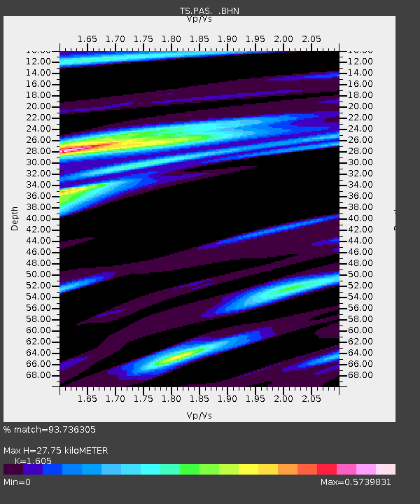
| Estimated Moho Depth: |
27.75 km |
| Estimated Crust Vp/Vs: |
1.61 |
| Assumed Crust Vp: |
6.1 km/s |
| Estimated Crust Vs: |
3.801 km/s |
| Estimated Crust Poisson's Ratio: |
0.18 |
|
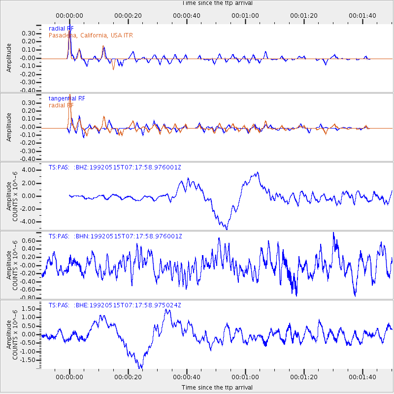
| Radial Match: |
93.736305 % |
| Radial Bump: |
400 |
| Transverse Match: |
74.064926 % |
| Transverse Bump: |
400 |
| SOD ConfigId: |
16938 |
| Insert Time: |
2010-02-26 14:34:39.898 +0000 |
| GWidth: |
2.5 |
| Max Bumps: |
400 |
| Tol: |
0.001 |
|
Signal To Noise
| Channel | StoN | STA | LTA |
| TS:PAS: :BHN:19920515T07:17:58.976001Z | 1.1841583 | 1.3388338E-7 | 1.1306206E-7 |
| TS:PAS: :BHE:19920515T07:17:58.975024Z | 1.190868 | 1.7294407E-7 | 1.4522521E-7 |
| TS:PAS: :BHZ:19920515T07:17:58.976001Z | 1.4119289 | 3.5665826E-7 | 2.5260357E-7 |
| Arrivals |
| Ps | 2.8 SECOND |
| PpPs | 12 SECOND |
| PsPs/PpSs | 14 SECOND |


