You are here: Home > Network List > TS - TERRAscope (Southern California Seismic Network) Stations List
> Station PAS Pasadena, California, USA > Earthquake Result Viewer
PAS Pasadena, California, USA - Earthquake Result Viewer
| Earthquake location: |
South Of Panama |
| Earthquake latitude/longitude: |
7.5/-82.3 |
| Earthquake time(UTC): |
1992/05/18 (139) 23:19:20 GMT |
| Earthquake Depth: |
11 km |
| Earthquake Magnitude: |
6.0 MB, 6.0 MS |
| Earthquake Catalog/Contributor: |
WHDF/NEIC |
|
| Network: |
TS TERRAscope (Southern California Seismic Network) |
| Station: |
PAS Pasadena, California, USA |
| Lat/Lon: |
34.15 N/118.17 W |
| Elevation: |
295 m |
|
| Distance: |
42.3 deg |
| Az: |
313.851 deg |
| Baz: |
120.441 deg |
| Ray Param: |
0.0732354 |
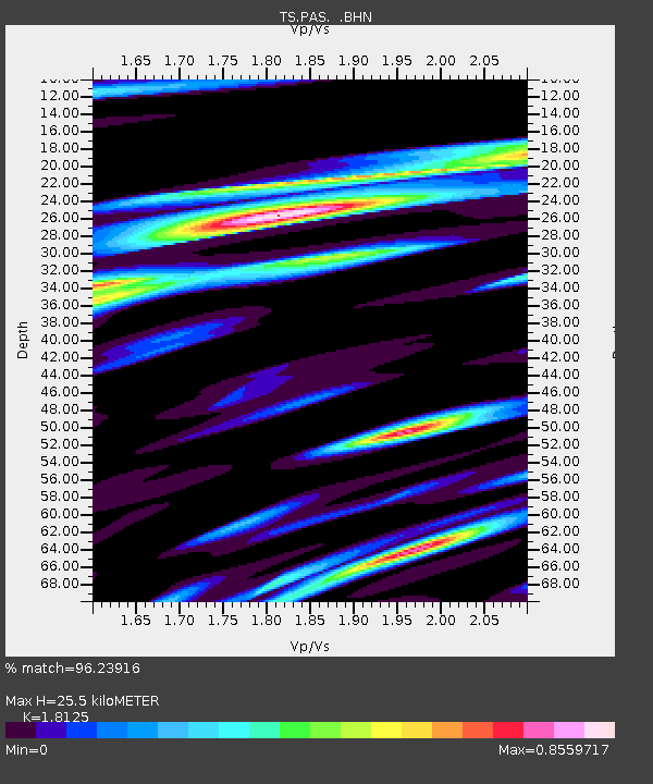
| Estimated Moho Depth: |
25.5 km |
| Estimated Crust Vp/Vs: |
1.81 |
| Assumed Crust Vp: |
6.1 km/s |
| Estimated Crust Vs: |
3.366 km/s |
| Estimated Crust Poisson's Ratio: |
0.28 |
|
| Radial Match: |
96.23916 % |
| Radial Bump: |
385 |
| Transverse Match: |
82.39157 % |
| Transverse Bump: |
400 |
| SOD ConfigId: |
16938 |
| Insert Time: |
2010-02-26 14:34:41.020 +0000 |
| GWidth: |
2.5 |
| Max Bumps: |
400 |
| Tol: |
0.001 |
|
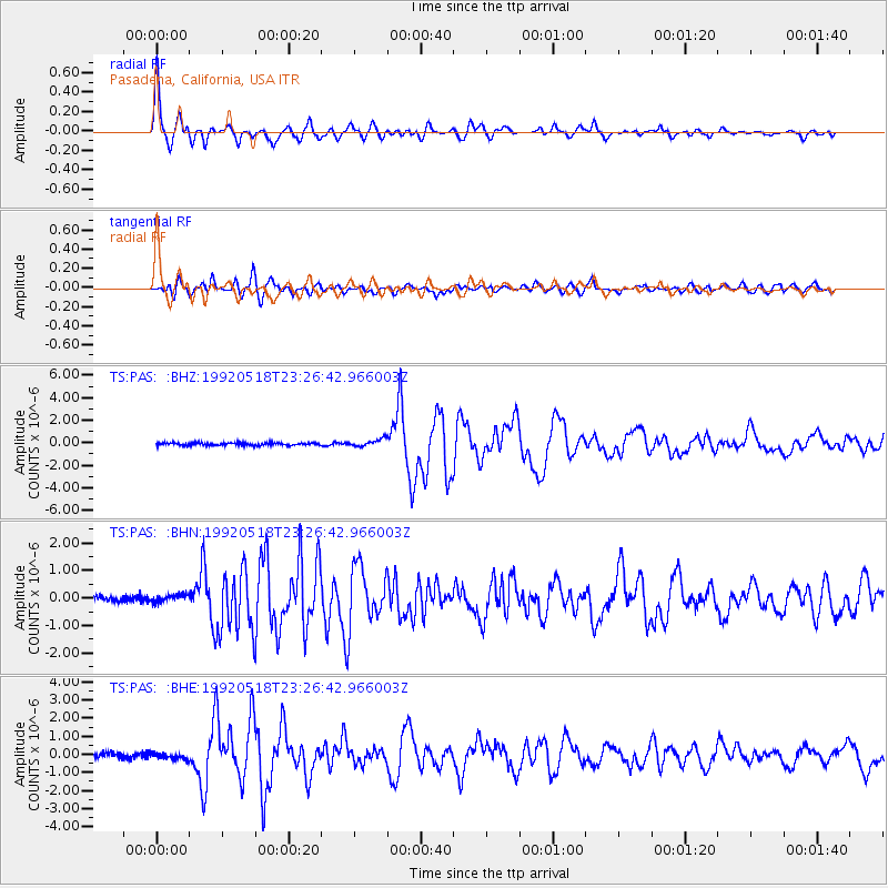
Signal To Noise
| Channel | StoN | STA | LTA |
| TS:PAS: :BHN:19920518T23:26:42.966003Z | 1.0448697 | 1.7970795E-7 | 1.7199078E-7 |
| TS:PAS: :BHE:19920518T23:26:42.966003Z | 0.9203512 | 1.8481556E-7 | 2.0080982E-7 |
| TS:PAS: :BHZ:19920518T23:26:42.966003Z | 2.9021528 | 3.3281168E-7 | 1.1467751E-7 |
| Arrivals |
| Ps | 3.6 SECOND |
| PpPs | 11 SECOND |
| PsPs/PpSs | 15 SECOND |


