You are here: Home > Network List > AU - Australian Seismological Centre Stations List
> Station PSAB3 Pilbara Seismic Array Element B3 > Earthquake Result Viewer
PSAB3 Pilbara Seismic Array Element B3 - Earthquake Result Viewer
| Earthquake location: |
West Of Macquarie Island |
| Earthquake latitude/longitude: |
-60.1/150.3 |
| Earthquake time(UTC): |
2017/03/09 (068) 11:14:26 GMT |
| Earthquake Depth: |
10 km |
| Earthquake Magnitude: |
5.9 Mww |
| Earthquake Catalog/Contributor: |
NEIC PDE/us |
|
| Network: |
AU Australian Seismological Centre |
| Station: |
PSAB3 Pilbara Seismic Array Element B3 |
| Lat/Lon: |
21.59 S/119.85 E |
| Elevation: |
327 m |
|
| Distance: |
44.1 deg |
| Az: |
317.338 deg |
| Baz: |
158.636 deg |
| Ray Param: |
0.07212961 |
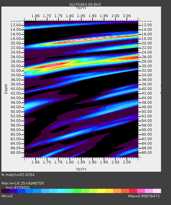
| Estimated Moho Depth: |
18.25 km |
| Estimated Crust Vp/Vs: |
1.87 |
| Assumed Crust Vp: |
6.464 km/s |
| Estimated Crust Vs: |
3.452 km/s |
| Estimated Crust Poisson's Ratio: |
0.30 |
|
| Radial Match: |
92.8254 % |
| Radial Bump: |
345 |
| Transverse Match: |
62.122158 % |
| Transverse Bump: |
400 |
| SOD ConfigId: |
1992691 |
| Insert Time: |
2017-03-23 11:14:55.157 +0000 |
| GWidth: |
2.5 |
| Max Bumps: |
400 |
| Tol: |
0.001 |
|

Signal To Noise
| Channel | StoN | STA | LTA |
| AU:PSAB3:00:BHZ:20170309T11:22:03.743995Z | 9.455936 | 1.7926795E-6 | 1.8958245E-7 |
| AU:PSAB3:00:BH1:20170309T11:22:03.743995Z | 5.510472 | 8.24354E-7 | 1.4959771E-7 |
| AU:PSAB3:00:BH2:20170309T11:22:03.743995Z | 6.494826 | 8.148789E-7 | 1.2546586E-7 |
| Arrivals |
| Ps | 2.6 SECOND |
| PpPs | 7.6 SECOND |
| PsPs/PpSs | 10 SECOND |


