You are here: Home > Network List > TS - TERRAscope (Southern California Seismic Network) Stations List
> Station PAS Pasadena, California, USA > Earthquake Result Viewer
PAS Pasadena, California, USA - Earthquake Result Viewer
| Earthquake location: |
Cuba Region |
| Earthquake latitude/longitude: |
19.6/-77.9 |
| Earthquake time(UTC): |
1992/05/25 (146) 16:55:05 GMT |
| Earthquake Depth: |
33 km |
| Earthquake Magnitude: |
6.3 MB, 7.0 MS |
| Earthquake Catalog/Contributor: |
WHDF/NEIC |
|
| Network: |
TS TERRAscope (Southern California Seismic Network) |
| Station: |
PAS Pasadena, California, USA |
| Lat/Lon: |
34.15 N/118.17 W |
| Elevation: |
295 m |
|
| Distance: |
38.5 deg |
| Az: |
300.504 deg |
| Baz: |
101.615 deg |
| Ray Param: |
0.075452834 |
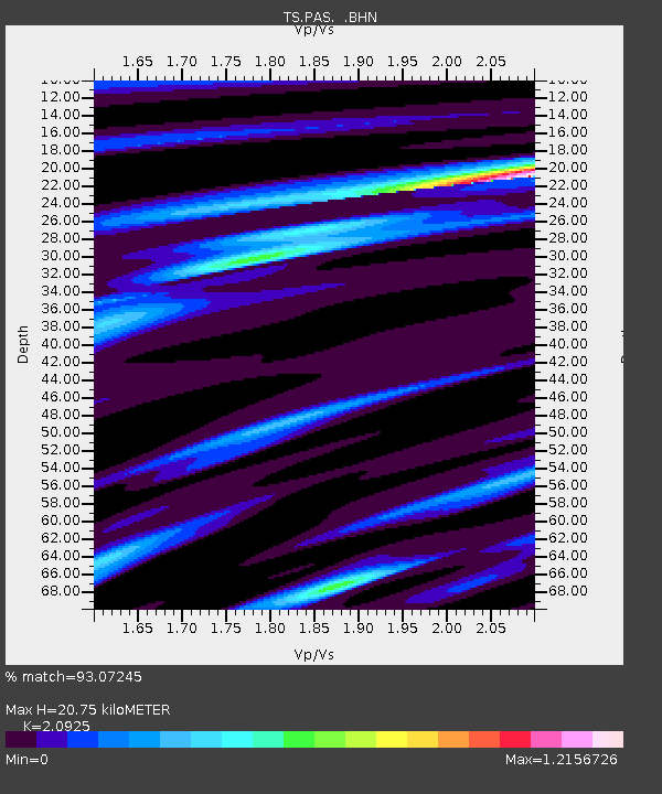
| Estimated Moho Depth: |
20.75 km |
| Estimated Crust Vp/Vs: |
2.09 |
| Assumed Crust Vp: |
6.1 km/s |
| Estimated Crust Vs: |
2.915 km/s |
| Estimated Crust Poisson's Ratio: |
0.35 |
|
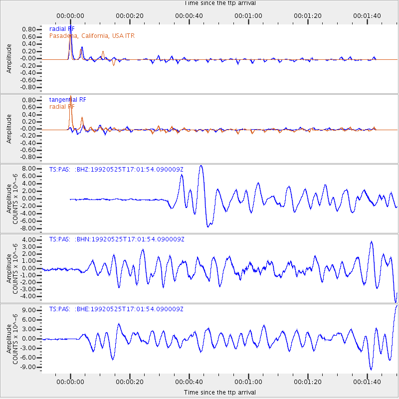
| Radial Match: |
93.07245 % |
| Radial Bump: |
195 |
| Transverse Match: |
72.32223 % |
| Transverse Bump: |
400 |
| SOD ConfigId: |
16938 |
| Insert Time: |
2010-02-26 14:34:42.117 +0000 |
| GWidth: |
2.5 |
| Max Bumps: |
400 |
| Tol: |
0.001 |
|
Signal To Noise
| Channel | StoN | STA | LTA |
| TS:PAS: :BHN:19920525T17:01:54.090009Z | 1.9722078 | 2.2257043E-7 | 1.1285345E-7 |
| TS:PAS: :BHE:19920525T17:01:54.090009Z | 7.3294697 | 6.8050105E-7 | 9.2844516E-8 |
| TS:PAS: :BHZ:19920525T17:01:54.090009Z | 11.538996 | 1.1440801E-6 | 9.914903E-8 |
| Arrivals |
| Ps | 3.9 SECOND |
| PpPs | 10.0 SECOND |
| PsPs/PpSs | 14 SECOND |


