You are here: Home > Network List > AU - Australian Seismological Centre Stations List
> Station PSAD1 Pilbara Seismic Array Element D1 > Earthquake Result Viewer
PSAD1 Pilbara Seismic Array Element D1 - Earthquake Result Viewer
| Earthquake location: |
West Of Macquarie Island |
| Earthquake latitude/longitude: |
-60.1/150.3 |
| Earthquake time(UTC): |
2017/03/09 (068) 11:14:26 GMT |
| Earthquake Depth: |
10 km |
| Earthquake Magnitude: |
5.9 Mww |
| Earthquake Catalog/Contributor: |
NEIC PDE/us |
|
| Network: |
AU Australian Seismological Centre |
| Station: |
PSAD1 Pilbara Seismic Array Element D1 |
| Lat/Lon: |
21.46 S/119.83 E |
| Elevation: |
280 m |
|
| Distance: |
44.2 deg |
| Az: |
317.38 deg |
| Baz: |
158.674 deg |
| Ray Param: |
0.072045654 |
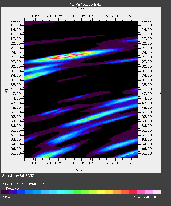
| Estimated Moho Depth: |
25.25 km |
| Estimated Crust Vp/Vs: |
1.79 |
| Assumed Crust Vp: |
6.464 km/s |
| Estimated Crust Vs: |
3.611 km/s |
| Estimated Crust Poisson's Ratio: |
0.27 |
|
| Radial Match: |
89.83554 % |
| Radial Bump: |
326 |
| Transverse Match: |
66.994194 % |
| Transverse Bump: |
400 |
| SOD ConfigId: |
1992691 |
| Insert Time: |
2017-03-23 11:14:58.922 +0000 |
| GWidth: |
2.5 |
| Max Bumps: |
400 |
| Tol: |
0.001 |
|

Signal To Noise
| Channel | StoN | STA | LTA |
| AU:PSAD1:00:BHZ:20170309T11:22:04.844001Z | 8.840948 | 1.7227991E-6 | 1.9486588E-7 |
| AU:PSAD1:00:BH1:20170309T11:22:04.844001Z | 4.8463497 | 9.146154E-7 | 1.8872254E-7 |
| AU:PSAD1:00:BH2:20170309T11:22:04.844001Z | 5.571263 | 8.16642E-7 | 1.4658113E-7 |
| Arrivals |
| Ps | 3.3 SECOND |
| PpPs | 10 SECOND |
| PsPs/PpSs | 14 SECOND |


