You are here: Home > Network List > TA - USArray Transportable Network (new EarthScope stations) Stations List
> Station W15A Williams, AZ, USA > Earthquake Result Viewer
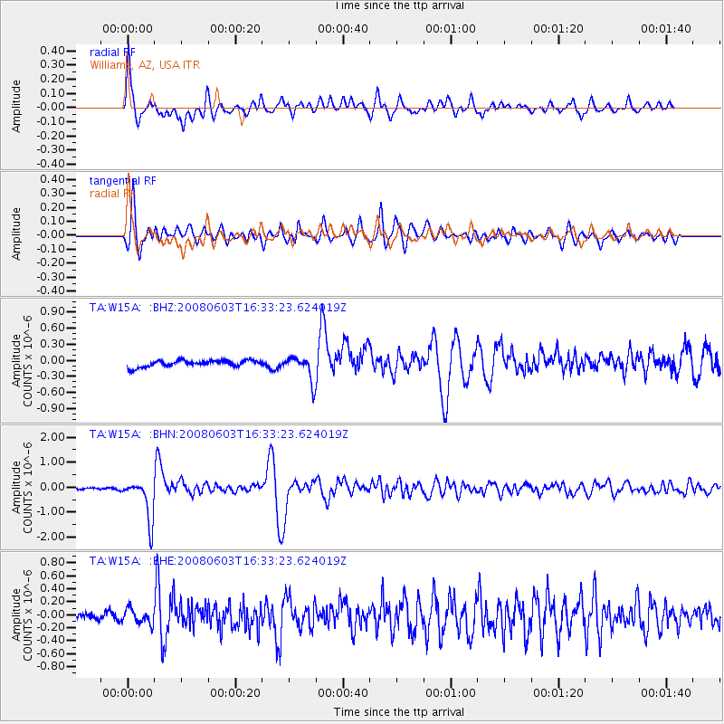
W15A Williams, AZ, USA - Earthquake Result Viewer
*The percent match for this event was below the threshold and hence no stack was calculated.
| Earthquake location: |
Solomon Islands |
| Earthquake latitude/longitude: |
-10.5/161.3 |
| Earthquake time(UTC): |
2008/06/03 (155) 16:20:50 GMT |
| Earthquake Depth: |
84 km |
| Earthquake Magnitude: |
6.2 MB, 6.2 MW, 6.2 MW |
| Earthquake Catalog/Contributor: |
WHDF/NEIC |
|
| Network: |
TA USArray Transportable Network (new EarthScope stations) |
| Station: |
W15A Williams, AZ, USA |
| Lat/Lon: |
35.18 N/112.27 W |
| Elevation: |
2034 m |
|
| Distance: |
93.1 deg |
| Az: |
54.966 deg |
| Baz: |
259.424 deg |
| Ray Param: |
$rayparam |
*The percent match for this event was below the threshold and hence was not used in the summary stack. |
|
| Radial Match: |
88.088875 % |
| Radial Bump: |
400 |
| Transverse Match: |
84.938576 % |
| Transverse Bump: |
400 |
| SOD ConfigId: |
2504 |
| Insert Time: |
2010-03-07 05:57:59.103 +0000 |
| GWidth: |
2.5 |
| Max Bumps: |
400 |
| Tol: |
0.001 |
|
Signal To Noise
| Channel | StoN | STA | LTA |
| TA:W15A: :BHN:20080603T16:33:23.624019Z | 21.152786 | 8.4018126E-7 | 3.971965E-8 |
| TA:W15A: :BHE:20080603T16:33:23.624019Z | 1.6627704 | 1.13778526E-7 | 6.8427084E-8 |
| TA:W15A: :BHZ:20080603T16:33:23.624019Z | 3.9214385 | 2.3774193E-7 | 6.0626206E-8 |
| Arrivals |
| Ps | |
| PpPs | |
| PsPs/PpSs | |


