You are here: Home > Network List > TA - USArray Transportable Network (new EarthScope stations) Stations List
> Station W15A Williams, AZ, USA > Earthquake Result Viewer
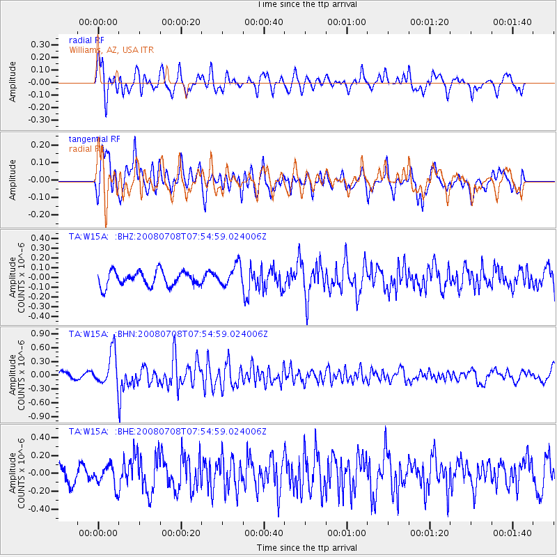
W15A Williams, AZ, USA - Earthquake Result Viewer
*The percent match for this event was below the threshold and hence no stack was calculated.
| Earthquake location: |
Ryukyu Islands, Japan |
| Earthquake latitude/longitude: |
27.5/128.3 |
| Earthquake time(UTC): |
2008/07/08 (190) 07:42:10 GMT |
| Earthquake Depth: |
43 km |
| Earthquake Magnitude: |
6.0 MB, 5.5 MS, 6.0 MW, 6.0 MW |
| Earthquake Catalog/Contributor: |
WHDF/NEIC |
|
| Network: |
TA USArray Transportable Network (new EarthScope stations) |
| Station: |
W15A Williams, AZ, USA |
| Lat/Lon: |
35.18 N/112.27 W |
| Elevation: |
2034 m |
|
| Distance: |
95.4 deg |
| Az: |
45.792 deg |
| Baz: |
309.008 deg |
| Ray Param: |
$rayparam |
*The percent match for this event was below the threshold and hence was not used in the summary stack. |
|
| Radial Match: |
72.979004 % |
| Radial Bump: |
400 |
| Transverse Match: |
75.52121 % |
| Transverse Bump: |
400 |
| SOD ConfigId: |
2504 |
| Insert Time: |
2010-03-07 05:58:04.280 +0000 |
| GWidth: |
2.5 |
| Max Bumps: |
400 |
| Tol: |
0.001 |
|
Signal To Noise
| Channel | StoN | STA | LTA |
| TA:W15A: :BHN:20080708T07:54:59.024006Z | 3.946663 | 3.828244E-7 | 9.699952E-8 |
| TA:W15A: :BHE:20080708T07:54:59.024006Z | 0.90111643 | 1.2011995E-7 | 1.3330126E-7 |
| TA:W15A: :BHZ:20080708T07:54:59.024006Z | 1.5020019 | 1.1157405E-7 | 7.428356E-8 |
| Arrivals |
| Ps | |
| PpPs | |
| PsPs/PpSs | |


