You are here: Home > Network List > TA - USArray Transportable Network (new EarthScope stations) Stations List
> Station W15A Williams, AZ, USA > Earthquake Result Viewer
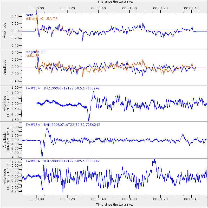
W15A Williams, AZ, USA - Earthquake Result Viewer
*The percent match for this event was below the threshold and hence no stack was calculated.
| Earthquake location: |
Fiji Islands Region |
| Earthquake latitude/longitude: |
-17.3/-177.3 |
| Earthquake time(UTC): |
2008/07/19 (201) 22:39:52 GMT |
| Earthquake Depth: |
391 km |
| Earthquake Magnitude: |
5.9 MB, 6.4 MW, 6.4 MW |
| Earthquake Catalog/Contributor: |
WHDF/NEIC |
|
| Network: |
TA USArray Transportable Network (new EarthScope stations) |
| Station: |
W15A Williams, AZ, USA |
| Lat/Lon: |
35.18 N/112.27 W |
| Elevation: |
2034 m |
|
| Distance: |
80.8 deg |
| Az: |
48.801 deg |
| Baz: |
241.319 deg |
| Ray Param: |
$rayparam |
*The percent match for this event was below the threshold and hence was not used in the summary stack. |
|
| Radial Match: |
81.313515 % |
| Radial Bump: |
400 |
| Transverse Match: |
61.04071 % |
| Transverse Bump: |
400 |
| SOD ConfigId: |
2504 |
| Insert Time: |
2010-03-07 05:58:04.952 +0000 |
| GWidth: |
2.5 |
| Max Bumps: |
400 |
| Tol: |
0.001 |
|
Signal To Noise
| Channel | StoN | STA | LTA |
| TA:W15A: :BHN:20080719T22:50:52.725024Z | 13.198852 | 1.4828971E-6 | 1.1235046E-7 |
| TA:W15A: :BHE:20080719T22:50:52.725024Z | 2.4041514 | 4.5268314E-7 | 1.8829228E-7 |
| TA:W15A: :BHZ:20080719T22:50:52.725024Z | 4.856839 | 7.280196E-7 | 1.4989575E-7 |
| Arrivals |
| Ps | |
| PpPs | |
| PsPs/PpSs | |


