You are here: Home > Network List > IU - Global Seismograph Network (GSN - IRIS/USGS) Stations List
> Station PMG Port Moresby, New Guinea > Earthquake Result Viewer
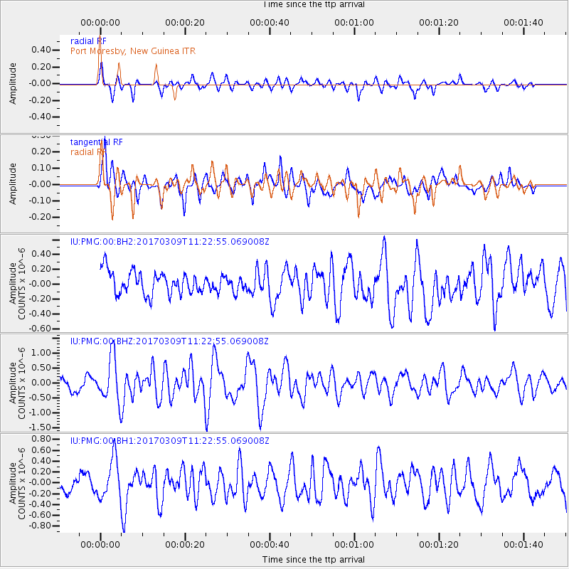
PMG Port Moresby, New Guinea - Earthquake Result Viewer
*The percent match for this event was below the threshold and hence no stack was calculated.
| Earthquake location: |
West Of Macquarie Island |
| Earthquake latitude/longitude: |
-60.1/150.3 |
| Earthquake time(UTC): |
2017/03/09 (068) 11:14:26 GMT |
| Earthquake Depth: |
10 km |
| Earthquake Magnitude: |
5.9 Mww |
| Earthquake Catalog/Contributor: |
NEIC PDE/us |
|
| Network: |
IU Global Seismograph Network (GSN - IRIS/USGS) |
| Station: |
PMG Port Moresby, New Guinea |
| Lat/Lon: |
9.40 S/147.16 E |
| Elevation: |
90 m |
|
| Distance: |
50.7 deg |
| Az: |
355.999 deg |
| Baz: |
177.973 deg |
| Ray Param: |
$rayparam |
*The percent match for this event was below the threshold and hence was not used in the summary stack. |
|
| Radial Match: |
66.77382 % |
| Radial Bump: |
400 |
| Transverse Match: |
71.92835 % |
| Transverse Bump: |
400 |
| SOD ConfigId: |
1992691 |
| Insert Time: |
2017-03-23 11:15:48.185 +0000 |
| GWidth: |
2.5 |
| Max Bumps: |
400 |
| Tol: |
0.001 |
|
Signal To Noise
| Channel | StoN | STA | LTA |
| IU:PMG:00:BHZ:20170309T11:22:55.069008Z | 3.5880914 | 7.654902E-7 | 2.1334189E-7 |
| IU:PMG:00:BH1:20170309T11:22:55.069008Z | 2.4075196 | 3.7551055E-7 | 1.5597405E-7 |
| IU:PMG:00:BH2:20170309T11:22:55.069008Z | 0.64478993 | 9.699778E-8 | 1.5043315E-7 |
| Arrivals |
| Ps | |
| PpPs | |
| PsPs/PpSs | |


