You are here: Home > Network List > TA - USArray Transportable Network (new EarthScope stations) Stations List
> Station W15A Williams, AZ, USA > Earthquake Result Viewer
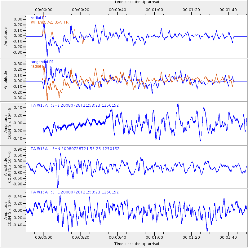
W15A Williams, AZ, USA - Earthquake Result Viewer
*The percent match for this event was below the threshold and hence no stack was calculated.
| Earthquake location: |
Solomon Islands |
| Earthquake latitude/longitude: |
-10.6/163.1 |
| Earthquake time(UTC): |
2008/07/28 (210) 21:40:47 GMT |
| Earthquake Depth: |
10 km |
| Earthquake Magnitude: |
5.9 MB, 5.8 MS, 6.0 MW |
| Earthquake Catalog/Contributor: |
WHDF/NEIC |
|
| Network: |
TA USArray Transportable Network (new EarthScope stations) |
| Station: |
W15A Williams, AZ, USA |
| Lat/Lon: |
35.18 N/112.27 W |
| Elevation: |
2034 m |
|
| Distance: |
91.7 deg |
| Az: |
54.679 deg |
| Baz: |
258.331 deg |
| Ray Param: |
$rayparam |
*The percent match for this event was below the threshold and hence was not used in the summary stack. |
|
| Radial Match: |
60.692997 % |
| Radial Bump: |
400 |
| Transverse Match: |
57.90571 % |
| Transverse Bump: |
400 |
| SOD ConfigId: |
2504 |
| Insert Time: |
2010-03-07 05:58:07.118 +0000 |
| GWidth: |
2.5 |
| Max Bumps: |
400 |
| Tol: |
0.001 |
|
Signal To Noise
| Channel | StoN | STA | LTA |
| TA:W15A: :BHN:20080728T21:53:23.125015Z | 1.3471432 | 1.3794612E-7 | 1.02399E-7 |
| TA:W15A: :BHE:20080728T21:53:23.125015Z | 1.9661846 | 1.9087221E-7 | 9.707746E-8 |
| TA:W15A: :BHZ:20080728T21:53:23.125015Z | 1.739209 | 1.4292978E-7 | 8.218091E-8 |
| Arrivals |
| Ps | |
| PpPs | |
| PsPs/PpSs | |


