You are here: Home > Network List > TA - USArray Transportable Network (new EarthScope stations) Stations List
> Station W15A Williams, AZ, USA > Earthquake Result Viewer
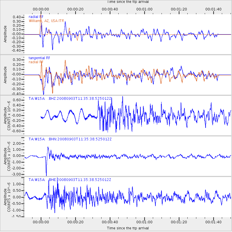
W15A Williams, AZ, USA - Earthquake Result Viewer
*The percent match for this event was below the threshold and hence no stack was calculated.
| Earthquake location: |
Santiago Del Estero Prov., Arg. |
| Earthquake latitude/longitude: |
-26.7/-63.2 |
| Earthquake time(UTC): |
2008/09/03 (247) 11:25:14 GMT |
| Earthquake Depth: |
570 km |
| Earthquake Magnitude: |
5.9 MB, 6.3 MW, 6.3 MW |
| Earthquake Catalog/Contributor: |
WHDF/NEIC |
|
| Network: |
TA USArray Transportable Network (new EarthScope stations) |
| Station: |
W15A Williams, AZ, USA |
| Lat/Lon: |
35.18 N/112.27 W |
| Elevation: |
2034 m |
|
| Distance: |
77.1 deg |
| Az: |
320.603 deg |
| Baz: |
136.14 deg |
| Ray Param: |
$rayparam |
*The percent match for this event was below the threshold and hence was not used in the summary stack. |
|
| Radial Match: |
67.25607 % |
| Radial Bump: |
400 |
| Transverse Match: |
79.47024 % |
| Transverse Bump: |
400 |
| SOD ConfigId: |
2504 |
| Insert Time: |
2010-03-07 05:58:11.412 +0000 |
| GWidth: |
2.5 |
| Max Bumps: |
400 |
| Tol: |
0.001 |
|
Signal To Noise
| Channel | StoN | STA | LTA |
| TA:W15A: :BHN:20080903T11:35:38.525012Z | 5.8498616 | 8.853371E-7 | 1.5134326E-7 |
| TA:W15A: :BHE:20080903T11:35:38.525012Z | 1.1999412 | 3.495095E-7 | 2.912722E-7 |
| TA:W15A: :BHZ:20080903T11:35:38.525012Z | 1.3865376 | 2.0182364E-7 | 1.4555944E-7 |
| Arrivals |
| Ps | |
| PpPs | |
| PsPs/PpSs | |


