You are here: Home > Network List > TS - TERRAscope (Southern California Seismic Network) Stations List
> Station PAS Pasadena, California, USA > Earthquake Result Viewer
PAS Pasadena, California, USA - Earthquake Result Viewer
| Earthquake location: |
Near Coast Of Chiapas, Mexico |
| Earthquake latitude/longitude: |
14.5/-92.9 |
| Earthquake time(UTC): |
1992/05/30 (151) 16:30:02 GMT |
| Earthquake Depth: |
57 km |
| Earthquake Magnitude: |
5.6 MB, 6.4 UNKNOWN |
| Earthquake Catalog/Contributor: |
WHDF/NEIC |
|
| Network: |
TS TERRAscope (Southern California Seismic Network) |
| Station: |
PAS Pasadena, California, USA |
| Lat/Lon: |
34.15 N/118.17 W |
| Elevation: |
295 m |
|
| Distance: |
30.1 deg |
| Az: |
315.024 deg |
| Baz: |
124.371 deg |
| Ray Param: |
0.07935272 |
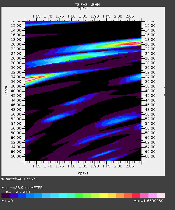
| Estimated Moho Depth: |
35.0 km |
| Estimated Crust Vp/Vs: |
1.61 |
| Assumed Crust Vp: |
6.1 km/s |
| Estimated Crust Vs: |
3.795 km/s |
| Estimated Crust Poisson's Ratio: |
0.18 |
|
| Radial Match: |
89.75673 % |
| Radial Bump: |
390 |
| Transverse Match: |
73.41871 % |
| Transverse Bump: |
400 |
| SOD ConfigId: |
16938 |
| Insert Time: |
2010-02-26 14:34:44.698 +0000 |
| GWidth: |
2.5 |
| Max Bumps: |
400 |
| Tol: |
0.001 |
|
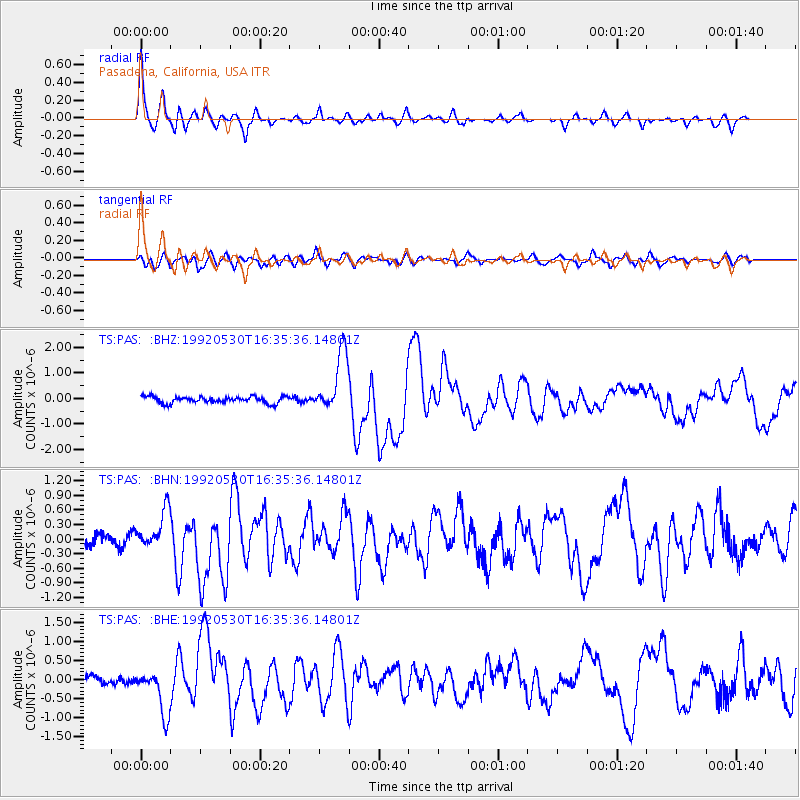
Signal To Noise
| Channel | StoN | STA | LTA |
| TS:PAS: :BHN:19920530T16:35:36.14801Z | 2.718502 | 4.018467E-7 | 1.4781916E-7 |
| TS:PAS: :BHE:19920530T16:35:36.14801Z | 3.730363 | 5.836249E-7 | 1.5645257E-7 |
| TS:PAS: :BHZ:19920530T16:35:36.14801Z | 9.204641 | 1.1868618E-6 | 1.2894166E-7 |
| Arrivals |
| Ps | 3.8 SECOND |
| PpPs | 14 SECOND |
| PsPs/PpSs | 18 SECOND |


