You are here: Home > Network List > TA - USArray Transportable Network (new EarthScope stations) Stations List
> Station P11A Cicrle Ranch, Eureka, NV, USA > Earthquake Result Viewer
P11A Cicrle Ranch, Eureka, NV, USA - Earthquake Result Viewer
| Earthquake location: |
Easter Island Region |
| Earthquake latitude/longitude: |
-28.5/-112.8 |
| Earthquake time(UTC): |
2008/08/19 (232) 10:58:00 GMT |
| Earthquake Depth: |
9.0 km |
| Earthquake Magnitude: |
5.5 MB, 5.3 MS, 5.7 MW, 5.7 MW |
| Earthquake Catalog/Contributor: |
WHDF/NEIC |
|
| Network: |
TA USArray Transportable Network (new EarthScope stations) |
| Station: |
P11A Cicrle Ranch, Eureka, NV, USA |
| Lat/Lon: |
39.55 N/115.75 W |
| Elevation: |
1787 m |
|
| Distance: |
67.8 deg |
| Az: |
357.569 deg |
| Baz: |
177.233 deg |
| Ray Param: |
0.05672104 |
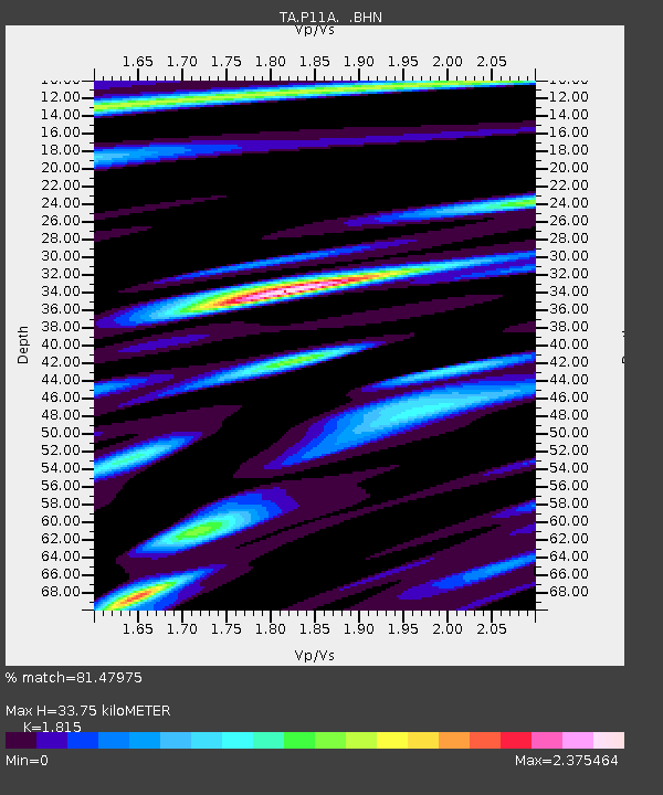
| Estimated Moho Depth: |
33.75 km |
| Estimated Crust Vp/Vs: |
1.82 |
| Assumed Crust Vp: |
6.276 km/s |
| Estimated Crust Vs: |
3.458 km/s |
| Estimated Crust Poisson's Ratio: |
0.28 |
|
| Radial Match: |
81.47975 % |
| Radial Bump: |
400 |
| Transverse Match: |
86.507324 % |
| Transverse Bump: |
400 |
| SOD ConfigId: |
2504 |
| Insert Time: |
2010-03-07 05:58:20.655 +0000 |
| GWidth: |
2.5 |
| Max Bumps: |
400 |
| Tol: |
0.001 |
|
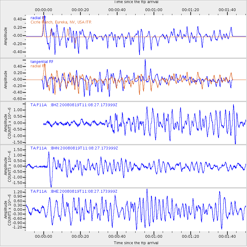
Signal To Noise
| Channel | StoN | STA | LTA |
| TA:P11A: :BHN:20080819T11:08:27.173999Z | 9.676316 | 8.124813E-7 | 8.3965965E-8 |
| TA:P11A: :BHE:20080819T11:08:27.173999Z | 3.3311934 | 4.6697642E-7 | 1.4018292E-7 |
| TA:P11A: :BHZ:20080819T11:08:27.173999Z | 0.95344967 | 1.0533513E-7 | 1.1047791E-7 |
| Arrivals |
| Ps | 4.5 SECOND |
| PpPs | 15 SECOND |
| PsPs/PpSs | 19 SECOND |


