You are here: Home > Network List > TA - USArray Transportable Network (new EarthScope stations) Stations List
> Station P11A Cicrle Ranch, Eureka, NV, USA > Earthquake Result Viewer
P11A Cicrle Ranch, Eureka, NV, USA - Earthquake Result Viewer
| Earthquake location: |
Kamchatka Peninsula, Russia |
| Earthquake latitude/longitude: |
52.1/157.3 |
| Earthquake time(UTC): |
2007/05/30 (150) 20:22:12 GMT |
| Earthquake Depth: |
116 km |
| Earthquake Magnitude: |
6.4 MB, 6.4 MW, 6.4 MW |
| Earthquake Catalog/Contributor: |
WHDF/NEIC |
|
| Network: |
TA USArray Transportable Network (new EarthScope stations) |
| Station: |
P11A Cicrle Ranch, Eureka, NV, USA |
| Lat/Lon: |
39.55 N/115.75 W |
| Elevation: |
1787 m |
|
| Distance: |
58.3 deg |
| Az: |
65.088 deg |
| Baz: |
313.695 deg |
| Ray Param: |
0.06255721 |
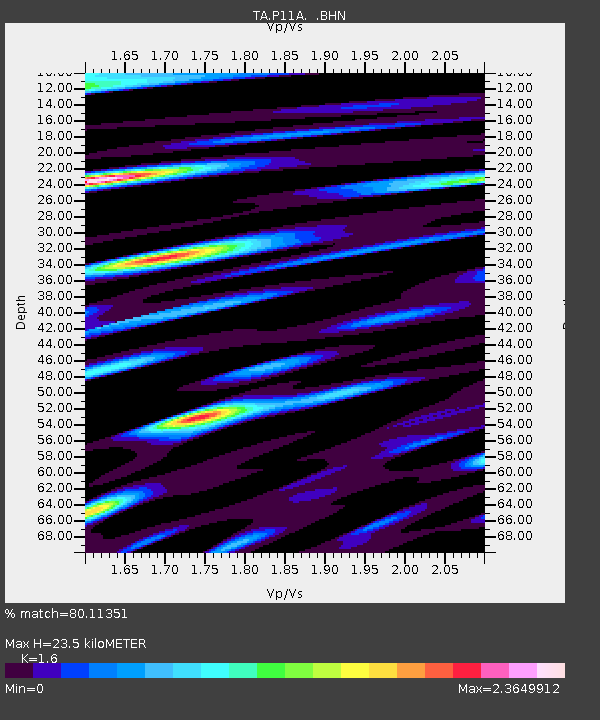
| Estimated Moho Depth: |
23.5 km |
| Estimated Crust Vp/Vs: |
1.60 |
| Assumed Crust Vp: |
6.276 km/s |
| Estimated Crust Vs: |
3.922 km/s |
| Estimated Crust Poisson's Ratio: |
0.18 |
|
| Radial Match: |
80.11351 % |
| Radial Bump: |
400 |
| Transverse Match: |
80.043335 % |
| Transverse Bump: |
400 |
| SOD ConfigId: |
2564 |
| Insert Time: |
2010-03-07 05:58:34.055 +0000 |
| GWidth: |
2.5 |
| Max Bumps: |
400 |
| Tol: |
0.001 |
|
Signal To Noise
| Channel | StoN | STA | LTA |
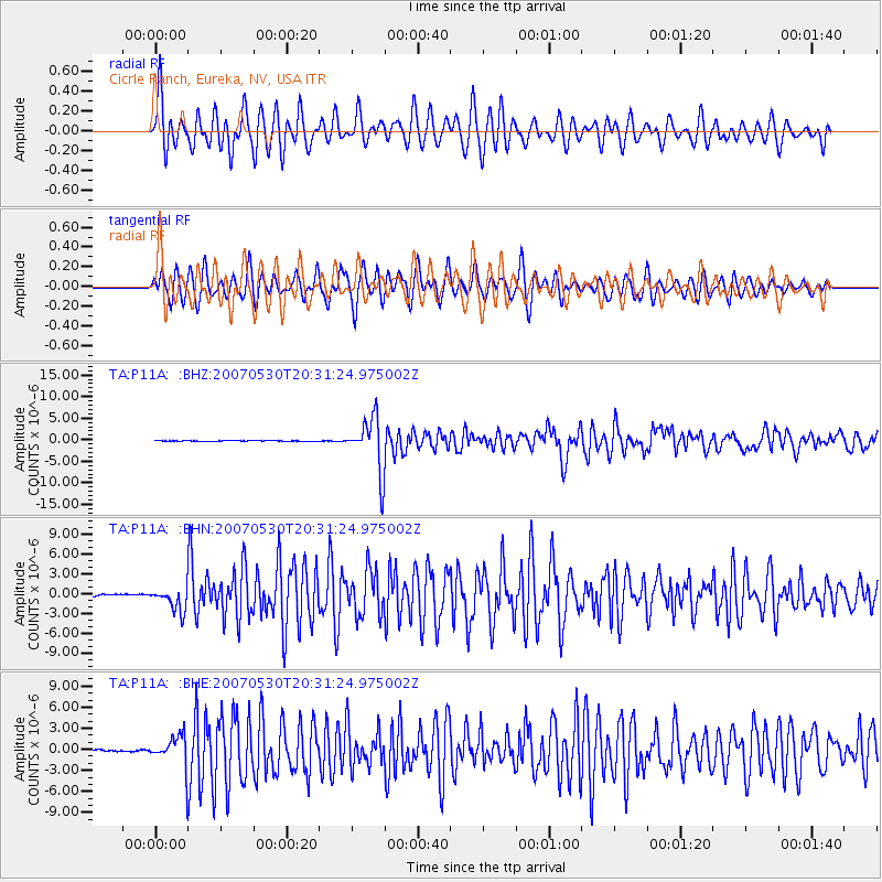
| TA:P11A: :BHN:20070530T20:31:24.975002Z | 11.260084 | 1.7263801E-6 | 1.5331858E-7 |
| TA:P11A: :BHE:20070530T20:31:24.975002Z | 10.986138 | 2.1844355E-6 | 1.9883561E-7 |
| TA:P11A: :BHZ:20070530T20:31:24.975002Z | 82.125565 | 6.236282E-6 | 7.5935944E-8 |
| Arrivals |
| Ps | 2.4 SECOND |
| PpPs | 9.3 SECOND |
| PsPs/PpSs | 12 SECOND |


