You are here: Home > Network List > TA - USArray Transportable Network (new EarthScope stations) Stations List
> Station P11A Cicrle Ranch, Eureka, NV, USA > Earthquake Result Viewer
P11A Cicrle Ranch, Eureka, NV, USA - Earthquake Result Viewer
| Earthquake location: |
Volcano Islands, Japan Region |
| Earthquake latitude/longitude: |
22.0/142.7 |
| Earthquake time(UTC): |
2007/09/28 (271) 13:38:59 GMT |
| Earthquake Depth: |
276 km |
| Earthquake Magnitude: |
6.7 MB, 7.4 MW, 7.4 MW |
| Earthquake Catalog/Contributor: |
WHDF/NEIC |
|
| Network: |
TA USArray Transportable Network (new EarthScope stations) |
| Station: |
P11A Cicrle Ranch, Eureka, NV, USA |
| Lat/Lon: |
39.55 N/115.75 W |
| Elevation: |
1787 m |
|
| Distance: |
84.7 deg |
| Az: |
49.515 deg |
| Baz: |
294.082 deg |
| Ray Param: |
0.04458872 |
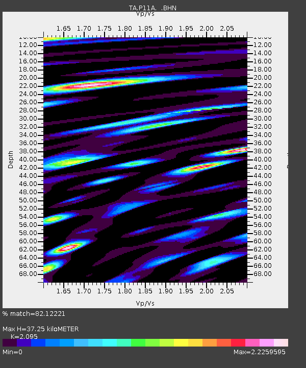
| Estimated Moho Depth: |
37.25 km |
| Estimated Crust Vp/Vs: |
2.10 |
| Assumed Crust Vp: |
6.276 km/s |
| Estimated Crust Vs: |
2.996 km/s |
| Estimated Crust Poisson's Ratio: |
0.35 |
|
| Radial Match: |
82.12221 % |
| Radial Bump: |
400 |
| Transverse Match: |
77.1592 % |
| Transverse Bump: |
400 |
| SOD ConfigId: |
2564 |
| Insert Time: |
2010-03-07 05:58:47.677 +0000 |
| GWidth: |
2.5 |
| Max Bumps: |
400 |
| Tol: |
0.001 |
|

Signal To Noise
| Channel | StoN | STA | LTA |
| TA:P11A: :BHN:20070928T13:50:31.425Z | 17.692528 | 3.1890472E-6 | 1.8024825E-7 |
| TA:P11A: :BHE:20070928T13:50:31.425Z | 40.115917 | 5.183951E-6 | 1.292243E-7 |
| TA:P11A: :BHZ:20070928T13:50:31.425Z | 123.69691 | 1.3243226E-5 | 1.070619E-7 |
| Arrivals |
| Ps | 6.6 SECOND |
| PpPs | 18 SECOND |
| PsPs/PpSs | 25 SECOND |


