You are here: Home > Network List > TA - USArray Transportable Network (new EarthScope stations) Stations List
> Station P11A Cicrle Ranch, Eureka, NV, USA > Earthquake Result Viewer
P11A Cicrle Ranch, Eureka, NV, USA - Earthquake Result Viewer

| Earthquake location: |
Near Coast Of Peru |
| Earthquake latitude/longitude: |
-13.5/-76.7 |
| Earthquake time(UTC): |
2006/10/20 (293) 10:48:56 GMT |
| Earthquake Depth: |
23 km |
| Earthquake Magnitude: |
5.9 MB, 6.6 MS, 6.7 MW, 6.6 MW |
| Earthquake Catalog/Contributor: |
WHDF/NEIC |
|
| Network: |
TA USArray Transportable Network (new EarthScope stations) |
| Station: |
P11A Cicrle Ranch, Eureka, NV, USA |
| Lat/Lon: |
39.55 N/115.75 W |
| Elevation: |
1787 m |
|
| Distance: |
64.1 deg |
| Az: |
327.187 deg |
| Baz: |
137.006 deg |
| Ray Param: |
0.059131637 |
| Estimated Moho Depth: |
53.25 km |
| Estimated Crust Vp/Vs: |
1.97 |
| Assumed Crust Vp: |
6.276 km/s |
| Estimated Crust Vs: |
3.19 km/s |
| Estimated Crust Poisson's Ratio: |
0.33 |
|
| Radial Match: |
83.06013 % |
| Radial Bump: |
400 |
| Transverse Match: |
77.44466 % |
| Transverse Bump: |
400 |
| SOD ConfigId: |
2564 |
| Insert Time: |
2010-03-07 05:58:55.954 +0000 |
| GWidth: |
2.5 |
| Max Bumps: |
400 |
| Tol: |
0.001 |
|
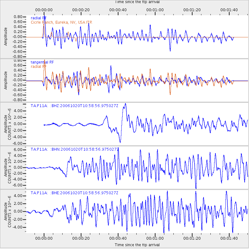
Signal To Noise
| Channel | StoN | STA | LTA |
| TA:P11A: :BHN:20061020T10:58:56.975027Z | 0.9607691 | 2.2964011E-7 | 2.3901697E-7 |
| TA:P11A: :BHE:20061020T10:58:56.975027Z | 2.5308142 | 6.271217E-7 | 2.4779445E-7 |
| TA:P11A: :BHZ:20061020T10:58:56.975027Z | 4.8483157 | 1.1965897E-6 | 2.4680523E-7 |
| Arrivals |
| Ps | 8.5 SECOND |
| PpPs | 24 SECOND |
| PsPs/PpSs | 33 SECOND |


